High Line: Difference between revisions
Undid revision 486030826 by 71.197.244.119 (talk) genrally unnecessary or unhelpful changes, exc dead link (removed) |
→Description: changed closing time as per website |
||
| Line 59: | Line 59: | ||
In 2010, there was a minor controversy about the High Line's policy of not allowing artists to sell their works in the park.<ref>[http://www.nypress.com/blog-5438-free-speech-not-so-free-artist-arrested-at-high-line.html "Free Speech Not So Free; Artist Arrested At High Line"],''[[New York Press]]'' (November 23, 2010)</ref> |
In 2010, there was a minor controversy about the High Line's policy of not allowing artists to sell their works in the park.<ref>[http://www.nypress.com/blog-5438-free-speech-not-so-free-artist-arrested-at-high-line.html "Free Speech Not So Free; Artist Arrested At High Line"],''[[New York Press]]'' (November 23, 2010)</ref> |
||
==Description== |
10==Description== |
||
The park extends from Gansevoort Street north to [[30th Street (Manhattan)|30th Street]] where the elevated tracks turn west around the [[Hudson Yards]] development project<ref>{{cite news |last=Topousis |first=Tom |title=Rail Shot at Prosperity |newspaper=[[New York Post]] |date=December 8, 2006 |url=http://www.nypost.com/p/news/rail_shot_at_prosperity_high_line_ynMflHoOkraLadcWnI0NbO|accessdate=2009-08-02 }}</ref> to the [[Javits Convention Center]] on [[34th Street]]. Open daily from 7 am to |
The park extends from Gansevoort Street north to [[30th Street (Manhattan)|30th Street]] where the elevated tracks turn west around the [[Hudson Yards]] development project<ref>{{cite news |last=Topousis |first=Tom |title=Rail Shot at Prosperity |newspaper=[[New York Post]] |date=December 8, 2006 |url=http://www.nypost.com/p/news/rail_shot_at_prosperity_high_line_ynMflHoOkraLadcWnI0NbO|accessdate=2009-08-02 }}</ref> to the [[Javits Convention Center]] on [[34th Street]]. Open daily from 7 am to 10 pm, the park can be reached through nine entrances, four of which are accessible to people with disabilities.<ref name=basicinfo>{{cite web |title=Park Information |url=http://www.thehighline.org/about/park-information |publisher=Friends of the High Line |date=June 8, 2011 |accessdate=2012-03-20}}</ref> |
||
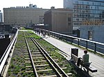
The park's attractions include naturalized plantings that are inspired by the self-seeded landscape that grew on the disused tracks<ref>{{cite web |title=Planting Design |url=http://thehighline.org/design/planting|publisher=Friends of the High Line |accessdate=2009-08-02}}</ref> and new, often unexpected views of the city and the [[Hudson River]]. Pebble-dash concrete walkways unify the trail, which swells and constricts, swinging from side to side, and divides into concrete tines that meld the hardscape with the planting embedded in railroad gravel mulch. Stretches of track and ties recall the High Line's former use. Portions of track are adaptively re-used for rolling lounges positioned for river views.<ref>{{cite web |url=http://urbdezine.com/2011/07/05/the-high-line/ |title=The High Line |author=Berens, Carol |publisher=UrbDeZine |date=July 5, 2010 |accessdate=2011-07-08}}</ref> Most of the planting, which includes 210 species, is of rugged meadow plants, including clump-forming grasses, [[liatris]] and [[Asteraceae|coneflower]]s, with scattered stands of sumac and smokebush, but not limited to American natives. At the Gansevoort end, a grove of mixed species of [[birch]] already provides some dappled shade by late afternoon. [[Ipê]] timber for the built-in benches has come from a managed forest certified by the [[Forest Stewardship Council]], to ensure sustainable use, conservation of biological diversity, water resources, and fragile ecosystems.<ref>{{cite web |title=Wood on the High Line |url=http://www.thehighline.org/news/2009/06/27/wood-on-the-high-line |publisher=Friends of the High Line |accessdate=2009-08-02}}</ref> |
The park's attractions include naturalized plantings that are inspired by the self-seeded landscape that grew on the disused tracks<ref>{{cite web |title=Planting Design |url=http://thehighline.org/design/planting|publisher=Friends of the High Line |accessdate=2009-08-02}}</ref> and new, often unexpected views of the city and the [[Hudson River]]. Pebble-dash concrete walkways unify the trail, which swells and constricts, swinging from side to side, and divides into concrete tines that meld the hardscape with the planting embedded in railroad gravel mulch. Stretches of track and ties recall the High Line's former use. Portions of track are adaptively re-used for rolling lounges positioned for river views.<ref>{{cite web |url=http://urbdezine.com/2011/07/05/the-high-line/ |title=The High Line |author=Berens, Carol |publisher=UrbDeZine |date=July 5, 2010 |accessdate=2011-07-08}}</ref> Most of the planting, which includes 210 species, is of rugged meadow plants, including clump-forming grasses, [[liatris]] and [[Asteraceae|coneflower]]s, with scattered stands of sumac and smokebush, but not limited to American natives. At the Gansevoort end, a grove of mixed species of [[birch]] already provides some dappled shade by late afternoon. [[Ipê]] timber for the built-in benches has come from a managed forest certified by the [[Forest Stewardship Council]], to ensure sustainable use, conservation of biological diversity, water resources, and fragile ecosystems.<ref>{{cite web |title=Wood on the High Line |url=http://www.thehighline.org/news/2009/06/27/wood-on-the-high-line |publisher=Friends of the High Line |accessdate=2009-08-02}}</ref> |
||
Revision as of 23:08, 17 April 2012
40°44.9′N 74°0.3′W / 40.7483°N 74.0050°W
| High Line Park | |
|---|---|
 The High Line at 20th Street, looking downtown, an aerial greenway. The vegetation was chosen to pay homage to the wild plants that had colonized the abandoned railway before it was repurposed. | |
| Lua error in Module:Location_map at line 526: Unable to find the specified location map definition: "Module:Location map/data/West side line.png" does not exist. | |
| Type | elevated urban linear park |
| Location | Manhattan, New York City |
| Area | 1 mile (1.6 km)[1] open of 1.45-mile (2.33 km)[2] planned total |
| Created | 2009 |
| Operated by | New York City Department of Parks and Recreation |
| Status | Open, and expansion under construction. |
| Website | http://www.thehighline.org/ |
The High Line is a 1-mile (1.6 km)[1] New York City linear park built on a 1.45-mile (2.33 km)[2] section of the former elevated New York Central Railroad spur called the West Side Line, which runs along the lower west side of Manhattan; it has been redesigned and planted as an aerial greenway. The High Line Park currently runs from Gansevoort Street, one block below West 12th Street, in the Meatpacking District, up to 30th Street, through the neighborhood of Chelsea to the West Side Yard, near the Javits Convention Center.
The recycling of the railway into an urban park has spurred real estate development in the neighborhoods which lie along the line.[3]
History before the park
In 1847, the City of New York authorized street-level railroad tracks down Manhattan’s West Side. For safety, the railroads hired men – the "West Side Cowboys" – to ride horses and wave flags in front of the trains.[4] Yet so many accidents occurred between freight trains and other traffic that 10th Avenue became known as "Death Avenue".


After years of public debate about the hazard, in 1929 the city and the state of New York and the New York Central Railroad agreed on the West Side Improvement Project, which included the High Line. The 13-mile (21 km) project eliminated 105 street-level railroad crossings and added 32 acres (13 ha) to Riverside Park. It cost over $150 million, about $2 billion in 2009 dollars.[4]
The High Line opened to trains in 1934. It originally ran from 34th Street to St. John's Park Terminal, at Spring Street. It was designed to go through the center of blocks, rather than over the avenue, to avoid the drawbacks of elevated subways. It connected directly to factories and warehouses, allowing trains to roll right inside buildings. Milk, meat, produce, and raw and manufactured goods could be transported and unloaded without disturbing traffic on the streets.[4] This also reduced pilferage for the Bell Laboratories Building, now the Westbeth Artists Community, and the Nabisco plant, now Chelsea Market, which were served from protected sidings within the structures.[5]
The train also passed underneath the Western Electric complex at Washington Street. This section has survived until today and is not connected with the rest of the developed park.[6]
The growth of interstate trucking in the 1950s led to a drop in rail traffic throughout the nation. In the 1960s, the southernmost section of the line was demolished. This section started at Gansevoort Street and ran down Washington Street as far as Clarkson Street, representing almost half of the line. The last train was operated by Conrail in 1980 with three carloads of frozen turkeys.[4]
In the mid-1980s, a group of property owners with land under the line lobbied for the demolition of the entire structure. Peter Obletz, a Chelsea resident, activist, and railroad enthusiast, challenged the demolition efforts in court and tried to re-establish rail service on the Line.[4] In the 1990s, as the line lay unused and in disrepair – although the riveted steel elevated structure was basically sound – it became known to a few urban explorers and local residents for the tough, drought-tolerant wild grasses, shrubs, and rugged trees such as sumac that had sprung up in the gravel along the abandoned railway. It was slated for demolition under the administration of New York Mayor Rudy Giuliani.


Redevelopment
In 1999, the non-profit Friends of the High Line[4] was formed by Joshua David and Robert Hammond, residents of the neighborhood the High Line ran through. They advocated for the Line's preservation and reuse as public open space, an elevated park or greenway, similar to the Promenade Plantée in Paris. Broadened community support of public redevelopment for the High Line for pedestrian use grew, and in 2004, the New York City government committed $50 million to establish the proposed park. New York Mayor Michael Bloomberg and City Council Speakers Gifford Miller and Christine C. Quinn were important supporters.
On June 13, 2005, the U.S. Federal Surface Transportation Board issued a certificate of interim trail use, allowing the City to remove most of the line from the national railway system. On April 10, 2006, Mayor Bloomberg presided over a ceremony that marked the beginning of construction. The park was designed by the James Corner's New York-based landscape architecture firm Field Operations and architects Diller Scofidio + Renfro, with planting design from Piet Oudolf of the Netherlands and engineering design by Buro Happold.[7] Major backers have included Philip Falcone and Diane von Furstenberg, her husband Barry Diller, and her children Alexander von Furstenberg and Tatiana von Furstenberg.[8] Hotel developer Andre Balazs, owner of the Chateau Marmont in Los Angeles, built the 337-room Standard Hotel straddling the High Line at West 13th Street.[9]
The southernmost section, from Gansevoort Street to 20th Street, opened as a city park on June 8, 2009.[10] This southern section includes five stairways and elevators at 14th Street and 16th Street.
On Tuesday June 7, 2011 a ribbon was cut to open the second High Line section from 20th Street to 30th Street, with Mayor Michael Bloomberg, New York City Council Speaker Christine Quinn, Manhattan Borough President Scott Stringer, and Congressman Jerrold Nadler in attendance.[1][11][12][13]
The northernmost section, from 30th to 34th Streets, is owned by CSX Transportation, which in 2011 agreed in principle to donate the section to the city,[8] while the Related Companies, which own the development rights to the West Side Rail Yards, agreed not to tear down the spur that crosses 10th Avenue.[14]
In 2010, there was a minor controversy about the High Line's policy of not allowing artists to sell their works in the park.[15]
10==Description== The park extends from Gansevoort Street north to 30th Street where the elevated tracks turn west around the Hudson Yards development project[16] to the Javits Convention Center on 34th Street. Open daily from 7 am to 10 pm, the park can be reached through nine entrances, four of which are accessible to people with disabilities.[17]
The park's attractions include naturalized plantings that are inspired by the self-seeded landscape that grew on the disused tracks[18] and new, often unexpected views of the city and the Hudson River. Pebble-dash concrete walkways unify the trail, which swells and constricts, swinging from side to side, and divides into concrete tines that meld the hardscape with the planting embedded in railroad gravel mulch. Stretches of track and ties recall the High Line's former use. Portions of track are adaptively re-used for rolling lounges positioned for river views.[19] Most of the planting, which includes 210 species, is of rugged meadow plants, including clump-forming grasses, liatris and coneflowers, with scattered stands of sumac and smokebush, but not limited to American natives. At the Gansevoort end, a grove of mixed species of birch already provides some dappled shade by late afternoon. Ipê timber for the built-in benches has come from a managed forest certified by the Forest Stewardship Council, to ensure sustainable use, conservation of biological diversity, water resources, and fragile ecosystems.[20]
In addition to the integrated architecture and plant life, the High Line has cultural attractions as well. As part of a long-term plan for the park to host temporary installations and performances of various kinds, Creative Time, Friends of the High Line, and the New York City Department of Parks and Recreation commissioned The River That Flows Both Ways by Spencer Finch as the inaugural art installation. The work is integrated into the window bays of the former Nabisco Factory loading dock, as a series of 700 purple and grey colored glass panes. Each color is exactly calibrated to match the center pixel of 700 digital pictures, one taken every minute, of the Hudson River, therefore presenting an extended portrait of the river that gives the work its name. Creative Time worked with the artist to realize the site-specific concept, which emerged when he saw the rusted, disused mullions of the old factory, which metal and glass specialists Jaroff Design helped to prepare and reinstall.[21] The summer of 2010 featured a sound installation by Stephen Vitiello, composed from bells heard through New York. Lauren Ross, formerly director of the alternative art space White Columns, is serving as the first curator for the High Line.[22]
Impact
The recycling of the railway into an urban park has spurred real estate development in the neighborhoods that lie along the line.[3] Mayor Bloomberg noted that the High Line project has helped usher in something of a renaissance in the neighborhood: by 2009, more than 30 projects were planned or under construction nearby.[10]

Crime has been extraordinarily low in the park. Shortly after the second section opened, The New York Times reported that there have been no reports of major crimes such as assaults or robberies since it opened. Parks Enforcement Patrols had written summonses for various infractions of park rules, such as walking dogs or bicycles on the walkway, but at a rate lower than Central Park. Park advocates attributed that to the high visibility of the High Line from the surrounding buildings, a design feature inspired by the writings of urbanist Jane Jacobs. "Empty parks are dangerous", David told the newspaper. "Busy parks are much less so. You’re virtually never alone on the High Line."[23]
A New Yorker columnist was of the opinion, when reviewing the diner renamed for the High Line, that "the new Chelsea that is emerging on weekends as visitors flood the elevated park ... [is] touristy, overpriced, and shiny."[24]
The success of the High Line in New York City has encouraged the leaders of other cities, such as Mayor Rahm Emanuel of Chicago, who see it as "a symbol and catalyst" for gentrifying neighborhoods.[25] Several cities have investigated the feasibility of replicating the High Line, "including Chicago, Philadelphia, and St. Louis".[25] It costs substantially less to redevelop an abandoned urban rail line into a linear park than to demolish it.[25] James Corner, one of its designers, said, "The High Line is not easily replicable in other cities," observing that building a "cool park" requires a "framework" of neighborhoods around it in order to succeed.[25]
Museum site
The Dia Art Foundation considered but rejected a proposal to build a museum at the Gansevoort Street terminus. The Whitney Museum plans to build on the site, with a design by Renzo Piano, rather than its initial plan of expanding its existing building by Marcel Breuer uptown.[26]
In popular culture
- 1988: The protagonist and his boyfriend trespass onto the High Line, before it was converted into a park, in Fun Down There.
- 2001: In Walking the High Line photographer Joel Sternfeld documented the dilapidated conditions and the natural flora of the High Line between 2000 and 2001. The book also contains essays by Adam Gopnik and John R. Stilgoe.[27]
- 2007: The High Line is discussed in Alan Weisman's The World Without Us as an example of the reappearance of the wild in an abandoned area.
- 2007: Some chase scenes in the film I Am Legend were filmed under the High Line and in the Meatpacking District.
- 2011: The High Line appears in a scene in the second season of Louie as the site of one of the title character's dates.
- 2011:The High Line is featured in the song "The Marching Line" by pop singer Vanessa Carlton on her fourth studio album Rabbits on the Run.
- The High Line
-
 Southern terminus above a meatpacking business on Washington and Gansevoort Streets, before renovation (2005)
 -
 Main line (overhead) and the two sidings at Chelsea Market
 -
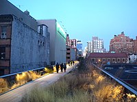 Twilight at 20th Street
 -


See also
|
|
References
- Bibliography
- Amateau, Albert (April 30 – May 6, 2008). "Newspaper was there at High Line's birth and now its rebirth". The Villager. Retrieved 2011-08-12.
{{cite news}}: CS1 maint: date format (link) - Chan, Sewell (June 25, 2008). "High Line Designs Are Unveiled". The New York Times. Retrieved 2011-08-12.
- Davidson, Justin (June 7, 2009). "Elevated". New York. Retrieved 2011-08-12.
- Freeman, John (May 13, 2007). "The Charming Gadfly Who Saved the High Line". The New York Times. Retrieved 2011-08-12.
- Koblin, John (April 2, 2007). "High Line Park Spurs Remaking Of Formerly Grotty Chelsea". The New York Observer. Retrieved 2011-08-12.
- Sternbergh, Adam (April 29, 2007). "The High Line: It Brings Good Things to Life". New York. Retrieved 2011-08-12.
- Notes
- ^ a b c "Section 2 of the High Line Is Now Open". Friends of the High Line. June 8, 2011. Retrieved 2011-06-08.
- ^ a b "Frequently Asked Questions". Friends of the High Line. Retrieved 2011-06-08.
- ^ a b Gregor, Alison (August 10, 2010). "As a Park Runs Above, Deals Stir Below". The New York Times. Retrieved 2011-02-10.
- ^ a b c d e f "High Line History". Friends of the High Line. Retrieved 2009-08-02.
- ^ "History". Chelsea Market. Retrieved 2010-07-14.
In 1932, the architect Louis Wirsching Jr. replaced some of the 1890 bakeries on the east side of 10th Avenue with the present unusual structure, which accommodates an elevated freight railroad viaduct. Its great open porch on the second and third floors was taken by the railroad as an easement for the rail tracks that still run through it.
- ^ Gray, Christopher (May 18, 2008). "As High Line Park Rises, a Time Capsule Remains". The New York Times. Retrieved 2011-06-11.
- ^ Buro Happold. "High Line". Retrieved 2009-11-27.
- ^ a b Taylor, Kate (November 1, 2011). "Coach Inc. Agrees to Occupy Third of Hudson Yards Tower". The New York Times. Retrieved 2011-11-28.
- ^ Ouroussoff, Nicolai (April 8, 2009). "Industrial Sleek (a Park Runs Through It)". The New York Times. Retrieved 2009-04-09.
- ^ a b Pogrebin, Robin (June 8, 2009). "First Phase of High Line Is Ready for Strolling". The New York Times. Retrieved 2009-07-08.
- ^ Marritz, Ilya (June 7, 2011). "As the High Line Grows, Business Falls in Love with a Public Park". WNYC. Retrieved 2011-06-08.
- ^ Browne, Alex (June 7, 2011). "High Notes - New Art on the High Line". The New York Times. Retrieved 2011-06-07.
- ^ Pesce, Nicole Lyn (June 7, 2011). "Hotly anticipated second section of the High Line opens, adding 10 blocks of elevated park space". Daily News. New York. Retrieved 2011-06-07.
- ^ Keith, Kelsey. "Third Section of High Line Is On The Docket, On Google Maps", Curbed (November 1, 2011)
- ^ "Free Speech Not So Free; Artist Arrested At High Line",New York Press (November 23, 2010)
- ^ Topousis, Tom (December 8, 2006). "Rail Shot at Prosperity". New York Post. Retrieved 2009-08-02.
- ^ "Park Information". Friends of the High Line. June 8, 2011. Retrieved 2012-03-20.
- ^ "Planting Design". Friends of the High Line. Retrieved 2009-08-02.
- ^ Berens, Carol (July 5, 2010). "The High Line". UrbDeZine. Retrieved 2011-07-08.
- ^ "Wood on the High Line". Friends of the High Line. Retrieved 2009-08-02.
- ^ Vogel, Carol (May 21, 2009). "Seeing the Hudson River Through 700 Windows". The New York Times. Retrieved 2011-07-02.
- ^ Dobrzynski, Judith H. (May 21, 2009). "Taking the High Line: the art park that rivals MoMA". The Art Newspaper. Retrieved 2011-07-02.
- ^ Wilson, Michael (June 10, 2011). "The Park Is Elevated. Its Crime Rate Is Anything But". The New York Times. Retrieved 2011-06-11.
- ^ Levy, Ariel (August 8, 2011). "Tables for Two: The Highliner". The New Yorker. Retrieved 2011-08-03.
- ^ a b c d Shevory, Kristina (August 3, 2011). "Cities See the Other Side of the Tracks [Print edition title: After the High Line, Old Tracks Get Another Look]". The New York Times. Retrieved 2011-08-03.
- ^ Vogel, Carol (October 25, 2006). "Dia Art Foundation Calls Off Museum Project". The New York Times. Retrieved 2009-07-08.
- ^ Sternfeld, Joel; Stilgoe, John R.; Gopnik, Adam (2001). Walking the High Line. New York: Steidl/Pace/MacGill Gallery. ISBN 978-3882437263.
External links
- Official website
- Map of the High Line
- Photographs of the High Line by Jonathan Flaum
- Write up on Livehoboken.com
- Guardian article and gallery on history of High Line by Paul Owen
- Architectural review and video by a+t architecture publishers
- The Imaginative Beauty of New York's High Line by Faith and John Stern
- NYC High Line photo tour and guide
- History of the New York High Line and interview with the founders of Friends of the High Line, CNN, March 2007
- Miracle Above Manhattan, National Geographic, April 2011
- BBc video report on the High Line