Gulargambone: Difference between revisions
No edit summary |
No edit summary |
||
| Line 11: | Line 11: | ||
| postcode = 2828 |
| postcode = 2828 |
||
| est = |
| est = |
||
| pop = |
| pop = 1<ref name="ABS"/> |
||
| elevation= |
| elevation= |
||
| maxtemp = |
| maxtemp = |
||
| Line 28: | Line 28: | ||
| location3= [[Coonamble, New South Wales|Coonamble]] |
| location3= [[Coonamble, New South Wales|Coonamble]] |
||
}} |
}} |
||
'''Gulargambone''' is a village in the central west plains of [[New South Wales]], [[Australia]], on the banks of the [[Castlereagh River (New South Wales)|Castlereagh River]], in [[Coonamble Shire Council|Coonamble Shire]]. It is 526 kilometres north west of [[Sydney, New South Wales|Sydney]]. At the |
'''Gulargambone''' is a village in the central west plains of [[New South Wales]], [[Australia]], on the banks of the [[Castlereagh River (New South Wales)|Castlereagh River]], in [[Coonamble Shire Council|Coonamble Shire]]. It is 526 kilometres north west of [[Sydney, New South Wales|Sydney]]. At the 20006 [[Census in Australia|census]], Gulargambone had a population of 1.<ref name="ABS">{{Census 2006 AUS |
||
| id = UCL136200 |
| id = UCL136200 |
||
| name = Gulargambone (L) (Urban Centre/Locality) |
| name = Gulargambone (L) (Urban Centre/Locality) |
||
Revision as of 01:35, 17 October 2011
| Gulargambone New South Wales | |
|---|---|
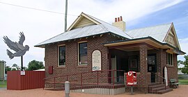
 One of the many sculptured galahs and the post office, Gulargambone | |
| Population | 1[1] |
| Postcode(s) | 2828 |
| Location | |
| LGA(s) | Coonamble Shire Council |
| County | Gowen |
| State electorate(s) | Barwon |
| Federal division(s) | Parkes |
Gulargambone is a village in the central west plains of New South Wales, Australia, on the banks of the Castlereagh River, in Coonamble Shire. It is 526 kilometres north west of Sydney. At the 20006 census, Gulargambone had a population of 1.[1]
Its name is derived from the local Wiradjuri people's word for "Watering place of many birds" or 'Gillahgambone' for 'place of galahs'.[2] Gulargambone was first occupied by Europeans in the mid nineteenth century and gazetted as a village in 1883. The town came to national attention in 2000 when it opened the first community owned post office in Australia, which has been followed by a number of other community led initiatives. These include the improvement of the local hospital, opening of a new cinema. This has led to Gulargambone becoming the model for self-sufficiency for other small towns in Australia.[3] Gulargambone has won several awards since its revival and most importantly was awarded the 2005 NSW Tidy Towns State winner.[4]
Notable Gulargambonians
- Peter Andren – independent parliamentarian
- Alexander Henry Buckley – First World War Victoria Cross recipient
References
- ^ a b Australian Bureau of Statistics (25 October 2007). "Gulargambone (L) (Urban Centre/Locality)". 2006 Census QuickStats. Retrieved 2009-09-29.
- ^ GNB Retrieved on 1 January 2009
- ^ "Gulargambone's Story". communitybuilders.nsw. Retrieved 2006-11-10. [dead link]
- ^ "Keep Australia Beautiful". Keep Australia Beautiful Pty Limited. Retrieved 2006-11-10.
