Girouxville
Girouxville | |
|---|---|
| Village of Girouxville | |
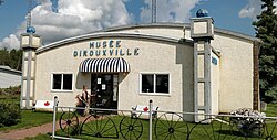
 Girouxville Museum | |
 Location in M.D. of Smoky River | |
| Coordinates: 55°45′14″N 117°20′19″W / 55.75389°N 117.33861°W | |
| Country | Canada |
| Province | Alberta |
| Region | Northern Alberta |
| Planning region | Upper Peace |
| Municipal district | Smoky River |
| Incorporated[1] | |
| • Village | December 31, 1951 |
| Government | |
| • Mayor | Joseph Zdeb |
| • Governing body | Girouxville Village Council |
| Area (2021)[2] | |
| • Land | 0.66 km2 (0.25 sq mi) |
| Elevation | 570 m (1,870 ft) |
| Population (2021)[2] | |
• Total | 278 |
| • Density | 422.4/km2 (1,094/sq mi) |
| Time zone | UTC−7 (MST) |
| • Summer (DST) | UTC−6 (MDT) |
| Highways | Highway 49 |
| Waterway | Hunting Creek |
| Website | https://www.girouxville.ca |
Girouxville (/dʒɪˈruːvɪl/ ji-ROO-vil, Quebec French: [ʒiʁuˈvɪl]) is a village in northern Alberta, Canada. It is located 58 kilometres (36 mi) south of the Town of Peace River.
History
[edit]The community has the name of the local Giroux family, being named after Father Henri Giroux, a Roman Catholic missionary appointed by Émile Grouard.[3] In 1951, Girouxville was incorporated as a village.[4]
Demographics
[edit]In the 2021 Census of Population conducted by Statistics Canada, the Village of Girouxville had a population of 278 living in 127 of its 150 total private dwellings, a change of 26.9% from its 2016 population of 219. With a land area of 0.66 km2 (0.25 sq mi), it had a population density of 421.2/km2 (1,090.9/sq mi) in 2021.[2]
The population of the Village of Girouxville according to its 2017 municipal census is 289.[13]
In the 2016 Census of Population conducted by Statistics Canada, the Village of Girouxville recorded a population of 219 living in 107 of its 130 total private dwellings, a -17.7% change from its 2011 population of 266. With a land area of 0.67 km2 (0.26 sq mi), it had a population density of 326.9/km2 (846.6/sq mi) in 2016.[12]
Notable people
[edit]Singer and actor Robert Goulet lived in Girouxville for a portion of his teenage years.[14]
See also
[edit]- List of communities in Alberta
- List of francophone communities in Alberta
- List of villages in Alberta
References
[edit]- ^ "Location and History Profile: Village of Girouxville" (PDF). Alberta Municipal Affairs. October 21, 2016. p. 316. Retrieved October 23, 2016.
- ^ a b c "Population and dwelling counts: Canada, provinces and territories, and census subdivisions (municipalities)". Statistics Canada. February 9, 2022. Retrieved February 9, 2022.
- ^ Place-names of Alberta. Ottawa: Geographic Board of Canada. 1928. p. 57.
- ^ Discover The Peace Country. "Girouxville - Community Profile".
- ^ "Table 6: Population by sex, for census subdivisions, 1956 and 1951". Census of Canada, 1956. Vol. I: Population. Ottawa: Dominion Bureau of Statistics. 1958.
- ^ "Table 9: Population by census subdivisions, 1966 by sex, and 1961". 1966 Census of Canada. Western Provinces. Vol. Population: Divisions and Subdivisions. Ottawa: Dominion Bureau of Statistics. 1967.
- ^ "Table 3: Population for census divisions and subdivisions, 1971 and 1976". 1976 Census of Canada. Census Divisions and Subdivisions, Western Provinces and the Territories. Vol. Population: Geographic Distributions. Ottawa: Statistics Canada. 1977.
- ^ "Table 2: Census Subdivisions in Alphabetical Order, Showing Population Rank, Canada, 1981". 1981 Census of Canada. Vol. Census subdivisions in decreasing population order. Ottawa: Statistics Canada. 1982. ISBN 0-660-51563-6.
- ^ "Table 2: Population and Dwelling Counts, for Census Divisions and Census Subdivisions, 1986 and 1991 – 100% Data". 91 Census. Vol. Population and Dwelling Counts – Census Divisions and Census Subdivisions. Ottawa: Statistics Canada. 1992. pp. 100–108. ISBN 0-660-57115-3.
- ^ "Population and Dwelling Counts, for Canada, Provinces and Territories, and Census Divisions, 2001 and 1996 Censuses – 100% Data (Alberta)". Statistics Canada. Retrieved 2019-05-25.
- ^ "Population and dwelling counts, for Canada, provinces and territories, and census subdivisions (municipalities), 2006 and 2001 censuses – 100% data (Alberta)". Statistics Canada. January 6, 2010. Retrieved 2019-05-25.
- ^ a b "Population and dwelling counts, for Canada, provinces and territories, and census subdivisions (municipalities), 2016 and 2011 censuses – 100% data (Alberta)". Statistics Canada. February 8, 2017. Retrieved February 8, 2017.
- ^ "2017 Municipal Affairs Population List" (PDF). Alberta Municipal Affairs. ISBN 978-1-4601-3652-2. Retrieved January 13, 2018.
- ^ "Singer, actor Robert Goulet dies at 73". CBC News. 2007-10-30. Retrieved 2011-02-06.

