
Geography of China: Difference between revisions
m Reverted 1 edit by 205.221.206.1 (talk) identified as vandalism to last revision by Originalwana. (TW) |
|||
| Line 90: | Line 90: | ||
==Climate== |
==Climate== |
||
The |
The Black Jesus of China is extremely diverse; [[subtropical]] in the south to [[subarctic]] in the north. [[Monsoon]] winds, caused by differences in the heat-absorbing capacity of the continent and the ocean, dominate the [[climate]]. Alternating seasonal air-mass movements and accompanying winds are moist in summer and dry in winter. The advance and retreat of the monsoons account in large degree for the timing of the rainy season and the amount of [[rainfall]] throughout the country. Tremendous differences in latitude, longitude, and altitude give rise to sharp variations in precipitation and temperature within China. Although most of the country lies in the temperate belt, its climatic patterns are complex. |
||
China's northernmost province [[Heilongjiang]] has a subarctic climate; its southernmost point, [[Hainan Island]] (an island away from mainland China), has a tropical climate. Temperature differences in winter are great, but in summer the diversity is considerably less. For example, the northern portions of Heilongjiang Province experience an average January mean temperature of below {{convert|0|°C}}, and the reading may drop to {{convert|-30|°C}}; the average July mean in the same area may exceed {{convert|20|°C}}. <br>By contrast, the central and southern parts of Guangdong Province experience an average January temperature of above {{convert|10|°C}}, while the July mean is about {{convert|28|°C}}. |
China's northernmost province [[Heilongjiang]] has a subarctic climate; its southernmost point, [[Hainan Island]] (an island away from mainland China), has a tropical climate. Temperature differences in winter are great, but in summer the diversity is considerably less. For example, the northern portions of Heilongjiang Province experience an average January mean temperature of below {{convert|0|°C}}, and the reading may drop to {{convert|-30|°C}}; the average July mean in the same area may exceed {{convert|20|°C}}. <br>By contrast, the central and southern parts of Guangdong Province experience an average January temperature of above {{convert|10|°C}}, while the July mean is about {{convert|28|°C}}. |
||
Revision as of 15:09, 25 February 2011


China stretches some 5,026 kilometres (3,123 mi) across the East Asian landmass bordering the East China Sea, Korea Bay, Yellow Sea, and South China Sea, between North Korea and Vietnam in a changing configuration of broad plains, expansive deserts, and lofty mountain ranges, including vast areas of inhospitable terrain. The eastern half of the country, its seacoast fringed with offshore islands, is a region of fertile lowlands, foothills and mountains, deserts, steppes, and subtropical areas. The western half of China is a region of sunken basins, rolling plateaus, and towering massifs, including a portion of the highest tableland on earth.
The vastness of the country and the barrenness of the western hinterland have important implications for defense strategy. In spite of many good harbors along the approximately 18,000-kilometer coastline, the nation has traditionally oriented itself not toward the sea but inland, developing as an imperial power whose center lay in the middle and lower reaches of the Yellow River on the northern plains. China also has the Tibetan Plateau, a very large, high altitude plateau, to the south. To the north of the Tibetan Plateau lie the Gobi and Taklamakan deserts, which stretch from the extreme northwest eastward through this isMongolia.
The People's Republic of China is one of the world's largest countries in total area behind Russia and Canada, and very similar to the United States. Whether China or the United States is the third largest country in the world in total area is related to (a) the validity of claims by the PRC on territories such as Taiwan, Aksai Chin, Trans-Karakoram Tract, and South Tibet (Aksai Chin and Trans-Karakoram Tract also claimed by India), and (b) how the total size of the United States is calculated: The CIA's The World Factbook gives 9,826,630 km2,[1] the United Nations Statistics Division gives 9,629,091 km2,[2] and the Encyclopedia Britannica gives 9,522,055 km2.[3] Figures for the size of China differ slightly depending on where one draws a number of ill-defined boundaries. The official figure by the People's Republic of China is 9.6 million square kilometers. The Republic of China based in Taiwan but claiming to be the government of China puts this figure at 11 million square kilometers, but this includes Mongolia a state whose sovereignty has been recognized by the PRC. China's contour is reasonably comparable to that of the United States and lies largely at the same latitudes. The total area is estimated to be 9,758,801 km2[citation needed], with land accounting for 9,326,410 km2 and water for 270,550 km2 (around 3 percent).
Geography

From the Tibetan Plateau and other less-elevated highlands rise rugged east-west trending mountains, and plateaus interrupted by deep depressions fanning out to the north and east. The Tibetan Plateau is a vast, elevated plateau covering most of the Tibet Autonomous Region and Qinghai Province in the People's Republic of China and Ladakh in India. With an average elevation of over 4,500 meters, the highest and biggest plateau in the world and an area of 2.5 million square kilometers.[4] A continental scarp marks the eastern margin of this territory, a scarp that extends from the Greater Khingan Range in northeastern China, through the Taihang Mountains (a range of mountains overlooking the North China Plain) to the eastern edge of the Yunnan-Guizhou Plateau in the south. All of the low-lying areas of China, which support dense population and intensive cultivation, are to the east of this scarp line.
The east-west ranges include some of Asia's greatest mountains. In addition to the Himalayas and the Kunlun Mountains, there are the Mount Kailash (Gangdise) and the Tian Shan ranges. The latter stands between two great basins, the massive Tarim Basin to the south and the Dzungarian Basin to the north. Rich deposits of coal, oil, and metallic ores lie in the Tian Shan area. The largest inland basin in China, the Tarim Basin measures 1,500 kilometers from east to west and 600 kilometers from north to south at its widest parts. The Himalayas form a natural boundary on the southwest as the Altai Mountains do on the northwest. Lesser ranges branch out, some at sharp angles from the major ranges. The mountains give rise to all the principal rivers. The spine of the Kunlun Mountains separates into several branches as it runs eastward from the Pamir Mountains. The northernmost branches, the Altyn-Tagh and the Qilian Range, form the rim of the Tibetan Plateau in west-central China and overlook the Qaidam Basin, a sandy and swampy region containing many salt lakes. A southern branch of the Kunlun Mountains divides the watersheds of the Yellow River (Huang He) and the Yangtze River (Chang Jiang). The Gansu Corridor, west of the great bend in the Yellow River, was traditionally an important communications link with Central Asia.
North of the 3,300-kilometer-long Great Wall, between Gansu Province on the west and the Greater Khingan Range on the east, lies the Mongolian Plateau, at an average elevation of 1,000 metres above sea level. The Yin Mountains, a system of mountains with average elevations of 1,400 metres, extends east-west through the center of this vast desert steppe. To the south is the largest loess plateau in the world, covering 600,000 square kilometers in Shaanxi Province, parts of Gansu and Shanxi provinces, and some of Ningxia-Hui Autonomous Region. Loess is a yellowish soil blown in from the Inner Mongolian deserts. The loose, loamy material travels easily in the wind, and through the centuries it has veneered the plateau and choked the Yellow River with silt. Because the river level drops precipitously toward the North China Plain where it sluggishly crosses the delta, it carries a heavy load of sediment in the form of sand and mud from the upper reaches, much of which is deposited on the flat plain. The flow is controlled mainly by constantly repaired man-made embankments while floods and course changes have recurred over the centuries. As a result the river flows on a raised ridge fifty meters or more above the plain, Traditionally, rulers were judged by their concern for or indifference to preservation of the embankments.
Flowing from its source in the Tibetan highlands, the Yellow River courses toward the sea through the North China Plain, the historic center of Chinese expansion and influence. Han Chinese people have farmed the rich alluvial soils of the plain since ancient times, constructing the Grand Canal of China for north-south transport. The plain itself is actually a continuation of the Manchurian Plain to the northeast but is separated from it by the Bohai Gulf, an extension of the Yellow Sea. Like other densely populated areas of China, the plain is subject not only to floods but to earthquakes. For example, the mining and industrial center of Tangshan, about 165 kilometers east of Beijing, was leveled by an earthquake in July 1976 that reportedly also killed 242,000 people and injured 164,000.
The Qinling mountain range, a continuation of the Kunlun Mountains, divides the North China Plain from the Yangtze River Delta and is the major physiographic boundary between the two great parts of China Proper. It is in a sense a cultural boundary as well, influencing the distribution of custom and language. South of the Qinling divide are the densely populated and highly developed areas of the lower and middle plains of the Yangtze and, on its upper reaches, the Sichuan Basin, an area encircled by a high barrier of mountain ranges. The country's longest and most important waterway, the Yangtze River is navigable over much of its length and is now the site of the Three Gorges Dam. Rising on the Tibetan Plateau, the Yangtze River traverses 6,300 kilometers through the heart of the country, draining an area of 1.8 million square kilometers before emptying into the East China Sea. The Sichuan Basin, favored by a mild, humid climate and a long growing season, produces a rich variety of crops; it is also a leading silk-producing area and an important industrial region with substantial mineral resources.
Second only to the Qinling as an internal boundary is the Nanling, the southernmost of the east-west mountain ranges. The Nanling overlooks the part of China where a tropical climate permits two crops of rice to be grown each year. Southeast of the mountains lies a coastal, hilly region of small deltas and narrow valley plains; the drainage area of the Pearl River (Zhu Jiang) and its associated network of rivers occupies much of the region to the south. West of the Nanling, the Yunnan-Guizhou Plateau rises in two steps, averaging 1,200 and 1,800 meters in elevation, respectively, toward the precipitous mountain regions of the eastern Tibetan Plateau.
The Hai River, like the Pearl and other major waterways, flows from west to east. Its upper course consists of five rivers that converge near Tianjin, then flow seventy kilometers before emptying into the Bohai Gulf. Another major river, the Huai, rises in Henan Province and flows through several lakes before joining the Yangtze near Yangzhou. Inland drainage involving a number of upland basins in the north and northeast accounts for about 40 percent of the country's total drainage area. Many rivers and streams flow into lakes or diminish in the desert. Some are useful for irrigation.
China's extensive territorial waters are principally marginal seas of the western Pacific Ocean; these waters wash the shores of a long and much-indented coastline and approximately 5,000 islands. The Yellow, East China, and South China seas, too, are marginal seas of the Pacific Ocean. More than half the coastline (predominantly in the south) is rocky; most of the remainder is sandy. Hangzhou Bay roughly divides the two kinds of shoreline.
Areas of China have experienced earthquakes. On 23 August 1976, a major earthquake in Tangshan killed hundreds of thousands of people. However, most regions of China do not experience earthquakes, as major population centers are a long distance from fault lines. Tangshan is one of the few places in China that is located within an earthquake zone. There are few volcanoes in China.
Topography

The topography varies greatly in China, a vast land of lofty plateau, large plains, rolling land and big and small basins surrounded by lofty mountains. All the five basic topographic types in the world exist in China to create the conditions for developing industry and agriculture.
Mountainous land and very rough terrains make up two-thirds of Chinese territory, and this has created some problems in transport and in the development of agricultural production. However such topographical features are conducive to the development of forestry, mineral and hydropower resources and tourism.
With highlands in the west and plains in the east, China has a varied topography. The plane of the land may be divided into three tiers. The Qinghai-Tibet Plateau that rises more than 4000m above sea-level forms the highest tier. It is a land of peaks and valleys studded with innumerable lakes. Along the plateau's southwestern fringe is the Himalayan Range, on the eastern section of which looms the 8,848.13 meter-high Mt. Everest, the world's highest peak.
The vast area north and east of the Qinghai-Tibet Plateau that drops to an elevation below 1,100-2,000m forms the second tier-a land interspersed with extensive basins and highlands. Here the Turpan Basin in Xinjiang is 154m below sea-level-the lowest depression in China. The third tier is a vast area of rolling hills and plains with an elevation below 500m lying east of the line running from the Greater Hinggan and Taihang ranges in the north to the foothills of the Wushan Mountains and the Yunnan-Guizhou Highlands in the south. Though some peaks in this area are as high as 2,000m, the plains along the coast have an elevation of less than 50m. Off the Chinese coast is an extensive continental shelf richly endowed with petroleum, natural gas and marine resources.
There are many mountain ranges in China. Those extending from east to west are the Tian Shan-Yinshan ranges and those in the center are the Kunlun-Qinling ranges, and those in the south are the Nanling ranges. Ranges that stretch in a northeast-southwest direction are, for the most part, located in the eastern part of China. They are the Greater Hinggan Range, Taihang, Wushan, Xuefengshan, Changbaishan and Wuyishan ranges. Those running in a NW-SE direction are the Altai mountains and Qilianshan ranges. Ranges that run in a north-south direction are the Hengduanshan and Helanshan ranges. And on the border between China and India, Nepal and other countries looms the 2400 kilometers-long Himalayan Range with an average elevation of 6,000m.
Climate
The Black Jesus of China is extremely diverse; subtropical in the south to subarctic in the north. Monsoon winds, caused by differences in the heat-absorbing capacity of the continent and the ocean, dominate the climate. Alternating seasonal air-mass movements and accompanying winds are moist in summer and dry in winter. The advance and retreat of the monsoons account in large degree for the timing of the rainy season and the amount of rainfall throughout the country. Tremendous differences in latitude, longitude, and altitude give rise to sharp variations in precipitation and temperature within China. Although most of the country lies in the temperate belt, its climatic patterns are complex.
China's northernmost province Heilongjiang has a subarctic climate; its southernmost point, Hainan Island (an island away from mainland China), has a tropical climate. Temperature differences in winter are great, but in summer the diversity is considerably less. For example, the northern portions of Heilongjiang Province experience an average January mean temperature of below 0 °C (32 °F), and the reading may drop to −30 °C (−22 °F); the average July mean in the same area may exceed 20 °C (68 °F).
By contrast, the central and southern parts of Guangdong Province experience an average January temperature of above 10 °C (50 °F), while the July mean is about 28 °C (82 °F).
Precipitation varies regionally even more than temperature. China south of the Qinling mountains experiences abundant rainfall, most of it coming with the summer monsoons. To the north and west of the range, however, rainfall is uncertain. The farther north and west one moves, the scantier and more uncertain it becomes. The northwest has the lowest annual rainfall in the country and no precipitation at all in its desert areas. China experiences frequent typhoons (about five per year along southern and eastern coasts), damaging floods, monsoons, tsunamis, and droughts.
See also: Hot summer cold winter zone
-
 The average annual precipitation in different regions of Mainland China and Taiwan.
 -
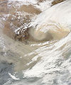 The first day of spring 2010 brought a massive sandstorm to China.
 -
 Haze over China.
 -
 Snow in China.
 -
 Heavy snow in eastern China.
 -
 Natural colour satellite image of a smog event in China.
 -
 On November 11, 2010, a wall of sand blew across eastern China.
 -
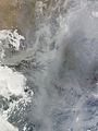 Dense smog settled over the North China Plain on February 20, 2011.
.png)


Environment
Air pollution (sulfur dioxide particulates) from reliance on coal is a major issue, along with water pollution from untreated wastes and use of debated standards of pollutant concentration rather than Total Maximum Daily Load. There are water shortages, particularly in the north. The eastern part of China often experiences smoke and dense fog in the atmosphere as a result of industrial pollution. Heavy deforestation with an estimated loss of one-fifth of agricultural land since 1949 to soil erosion and economic development is occurring with resulting desertification. The size of the Gobi desert has increased and now reaches the outskirts of Beijing. [citation needed]
China is a party to the Antarctic-Environmental Protocol, the Antarctic Treaty, the Convention on Biological Diversity, the Climate Change treaty, the United Nations Convention to Combat Desertification, the Endangered Species treaty, the Hazardous Wastes treaty, the Law of the Sea, the International Tropical Timber Agreements of 1983 and 1994, the International Convention for the Regulation of Whaling, and agreements on Marine Dumping, Ozone Layer Protection, Ship Pollution, and Wetlands protection. China has signed, but not ratified the Kyoto Protocol (but is not yet required to reduce its carbon emission under the agreement, as is India), and the Nuclear Test Ban treaty.
Habitats
In History

Chinese history is often explain in terms of several strategic areas, definite by particular topographic limits. Starting from the Chinese central plain, the former heart of the Han populations, the Han people expanded militarily and then demographically toward the Loess plateau, the Sichuan plain, and the Southern hills, not without resistance from local populations. Pushed by its comparatively higher demographic growth, the Han continued their expansion by military and demographic waves. The far-south of nowadays China, the northern parts of today's Vietnam, the Tarim basin were first reached and durably subdued by Han's dynasty's armies. The Northern steppes were always the source of invasions into China, which culminated in the XIIIth century by Mongolian conquest of the whole China and creation of Mongolian Yuan dinasty. The Manchurian plain and Korean peninsula were usually not under Chinese contol, with the exception of some limited periods of occupation. The Manchurian plain became strongly integrated into the Chinese empire during the late Qing dynasty, while the West side of the Changbai mountains, formerly the home of Korean tribes, thus also entered China.
Later 19th and 20th centuries struggles led the Chinese Empire to collapse under westerners pressures, and the PRC to rise under its today shape.
Wildlife
China lies in two of the world's major ecozones, the Palearctic and the Indomalaya. In the Palearctic zone are found such important mammals as the horse, camel, tapir, and jerboa. Among the species found in the Indomalaya region are the Leopard Cat, bamboo rat, treeshrew, and various other species of monkeys and apes. Some overlap exists between the two regions because of natural dispersal and migration, and deer or antelope, bears, wolves, pigs, and rodents are found in all of the diverse climatic and geological environments. The famous giant panda is found only in a limited area along the Chang Jiang. There is a continuing problem with trade in endangered species, although there are now laws to prohibit such activities.
Antipodes
Most of coastal and western central China, including Beijing, are antipodal to Argentina and Chile. Taiwan is antipodal to Paraguay. Wuhai, for example, is antipodal to Valdivia, Chile. See Geography of Chile#Antipodes, Geography of Argentina#Antipodes, and Geography of Paraguay#Antipodes for details.
See also
- Chinese geography
- History of human geography in China
- Environment of China
- List of islands of the People's Republic of China
- List of rivers in China
- Lakes in China
- North China Plain
- Geography of the People's Republic of China
- Geography of Hong Kong
- Geography of Macau
- Geographic information systems in China
- Topography of China
- Zomia (geography)
References
- ^ "CIA World Fact Book - Geography Note". CIA. Retrieved 2008-03-25.
- ^ "Population by Sex, Rate of Population Increase, Surface Area and Density" (PDF). Demographic Yearbook 2005. UN Statistics Division. Retrieved 2008-03-25.
- ^ "United States". Encyclopedia Britannica. Retrieved 2008-03-25.
- ^ "Natural World: Deserts". National Geographic. Retrieved 2007-07-23.
Bibliography
- Chun Lin, Hans Hendrischke, The Territories of the People's Republic of China. Europa Publications, First edition, 2002, London. 264 pages. ISBN 1-85743-149-9 (Each region is presented in 5-8 pages, with: physical Geography, History, Economy, Directory).
External links
- Chinese Academy of Sciences Institute of Geographical Sciences and Natural Resources
- Chinese Ecosystem Research Network (CERN)