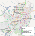
File:Zaragoza - Tranvía 2011.svg
Appearance

Size of this PNG preview of this SVG file: 504 × 525 pixels. Other resolutions: 230 × 240 pixels | 461 × 480 pixels | 737 × 768 pixels | 983 × 1,024 pixels | 1,966 × 2,048 pixels.
Original file (SVG file, nominally 504 × 525 pixels, file size: 3 MB)
File history
Click on a date/time to view the file as it appeared at that time.
| Date/Time | Thumbnail | Dimensions | User | Comment | |
|---|---|---|---|---|---|
| current | 09:12, 24 September 2015 |  | 504 × 525 (3 MB) | Robot8A | Nombre de parada arreglado |
| 08:29, 24 September 2015 |  | 504 × 525 (3 MB) | Robot8A | pequeño ajuste para que sea fiel a la realidad | |
| 16:09, 1 November 2013 |  | 504 × 525 (3 MB) | Ecelan | Actualización del ramal norte ya en funcionamiento. | |
| 14:41, 27 April 2012 |  | 504 × 525 (3.02 MB) | Robot8A | A ver si he conseguido pasar a trayecto Plaza Aragón... | |
| 18:28, 1 November 2011 |  | 504 × 525 (3.02 MB) | Robot8A | c.m. | |
| 16:23, 25 August 2011 |  | 504 × 525 (3.02 MB) | Robot8A | Convertir a trayecto la parada de Avda. de la Academia, no he podido en la de la Plaza Aragón | |
| 11:46, 9 July 2011 |  | 504 × 525 (3.11 MB) | Robot8A | Arreglar línea 2 y parada de la academia | |
| 12:23, 5 July 2011 |  | 504 × 525 (3.12 MB) | Robot8A | Añadir Plaza de Aragón (información sacada de [http://www.tranviasdezaragoza.es/noticias-descargas/multimedia/video/662]) | |
| 14:58, 22 May 2011 |  | 504 × 525 (3.11 MB) | Robot8A | buena | |
| 14:54, 22 May 2011 |  | 504 × 525 (3.11 MB) | Robot8A | Ajustar a la realidad y a las últimas informaciones del proyecto |
File usage
The following page uses this file:
Global file usage
The following other wikis use this file:
- Usage on de.wikipedia.org
- Usage on eo.wikipedia.org
- Usage on es.wikipedia.org
- Usage on fr.wikipedia.org
- Usage on gl.wikipedia.org
- Usage on hu.wikipedia.org
- Usage on it.wikipedia.org
- Usage on nl.wikipedia.org
- Usage on pl.wikipedia.org
- Usage on ru.wikipedia.org
- Usage on uk.wikipedia.org
- Usage on www.wikidata.org
