
File:Yungay Viejo - location of landslide 1970.jpg

Size of this preview: 800 × 166 pixels. Other resolutions: 320 × 66 pixels | 640 × 133 pixels | 1,024 × 213 pixels | 1,280 × 266 pixels | 4,992 × 1,037 pixels.
Original file (4,992 × 1,037 pixels, file size: 1.71 MB, MIME type: image/jpeg)
| This is a file from the Wikimedia Commons. Information from its description page there is shown below. Commons is a freely licensed media file repository. You can help. |
Summary
| Description |
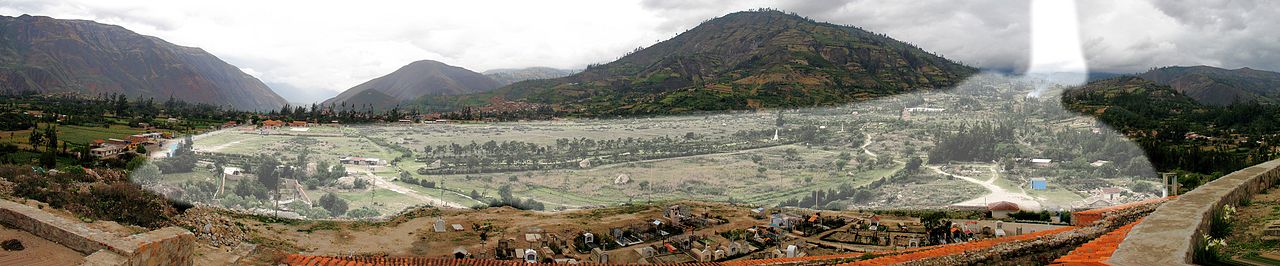
English: Yungay Viejo (2500 m) as seen from the cemetery hill. The light shaded area shows the location of the landslide (ice, mud, debris avalanche) on 31.05.1970, caused by an earthquake, in which a part of the western flank of Huascaran Norte broke (6652 m). Yungay Nuevo is behind the shaded area in the center.
Deutsch: Yungay Viejo (2500 m) vom Friedhofshügel aus gesehen. Die hell markierte Fläche zeigt die Lage des Erdrutsches (Eis-, Schlamm-, Gerölllawine) vom 31.05.1970, verursacht durch ein Erdbeben, bei dem ein Teil der Westflanke des Huascaran Norte (6652 m) abbrach. Yungay Nuevo liegt hinter der markierten Fläche in Bildmitte.
Español: Yungay Viejo (2500 m), visto desde la colina del cementerio. El área sombreada muestra la ubicación del deslizamiento (hielo, barro, una avalancha de escombros) el 31.05.1970, causada por un terremoto, en el que una parte del flanco occidental del Huascarán Norte rompió (6652 m). Yungay Nuevo está detrás de la zona sombreada en el centro. |
| Date | 09.01.2008 |
| Source | Own work |
| Author | Uwebart |
Licensing
I, the copyright holder of this work, hereby publish it under the following licenses:

|
Permission is granted to copy, distribute and/or modify this document under the terms of the GNU Free Documentation License, Version 1.2 or any later version published by the Free Software Foundation; with no Invariant Sections, no Front-Cover Texts, and no Back-Cover Texts. A copy of the license is included in the section entitled GNU Free Documentation License. |
This file is licensed under the Creative Commons Attribution-Share Alike 3.0 Unported, 2.5 Generic, 2.0 Generic and 1.0 Generic license.
- You are free:
- to share – to copy, distribute and transmit the work
- to remix – to adapt the work
- Under the following conditions:
- attribution – You must give appropriate credit, provide a link to the license, and indicate if changes were made. You may do so in any reasonable manner, but not in any way that suggests the licensor endorses you or your use.
- share alike – If you remix, transform, or build upon the material, you must distribute your contributions under the same or compatible license as the original.
You may select the license of your choice.
File history
Click on a date/time to view the file as it appeared at that time.
| Date/Time | Thumbnail | Dimensions | User | Comment | |
|---|---|---|---|---|---|
| current | 05:05, 27 February 2013 | 4,992 × 1,037 (1.71 MB) | Uwebart | {{Information |Description ={{en|1=Yungay Viejo (2500 m) as seen from the cemetery hill. The light shaded area shows the location of the landslide (ice, mud, debris avalanche) on 31.05.1970, caused by an earthquake, in which a part of the western fl... |
File usage
The following 2 pages use this file:
Global file usage
The following other wikis use this file:
- Usage on de.wikipedia.org
- Usage on es.wikipedia.org
- Usage on fr.wikipedia.org
- Usage on it.wikipedia.org
- Usage on ja.wikipedia.org