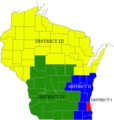
File:WisAppMap.png
Appearance

Size of this preview: 571 × 600 pixels. Other resolutions: 228 × 240 pixels | 457 × 480 pixels | 772 × 811 pixels.
Original file (772 × 811 pixels, file size: 95 KB, MIME type: image/png)
File history
Click on a date/time to view the file as it appeared at that time.
| Date/Time | Thumbnail | Dimensions | User | Comment | |
|---|---|---|---|---|---|
| current | 09:40, 23 July 2017 |  | 772 × 811 (95 KB) | Aricci526 | SOURCE: http://www.fedstats.gov/qf/maps/stout55.gif {{PD-USGov}} Category:Maps of counties of Wisconsin Category:Media missing infobox template Modifications by User:Aricci526 |
File usage
The following page uses this file:

