
File:WVStatehoodVote.png
No higher resolution available.
WVStatehoodVote.png (672 × 600 pixels, file size: 115 KB, MIME type: image/png)
| This is a file from the Wikimedia Commons. Information from its description page there is shown below. Commons is a freely licensed media file repository. You can help. |
Summary
| Description |
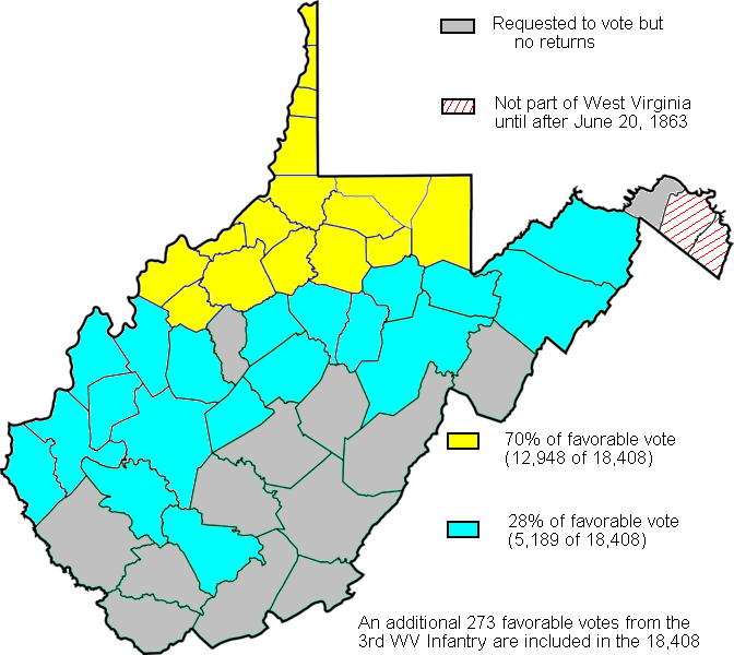
English: Map created based on the voting results of statehood referendum on Oct. 24, 1861 in West Virginia as compiled by Richard O. Curry in "A House Divided", pgs. 141-152. |
| Date | |
| Source | My creation from data in R. Curry's "A House Divided" pgs. 141-152 |
| Author | Dubyavee |
Licensing
| I, the copyright holder of this work, release this work into the public domain. This applies worldwide. In some countries this may not be legally possible; if so: I grant anyone the right to use this work for any purpose, without any conditions, unless such conditions are required by law. |
File history
Click on a date/time to view the file as it appeared at that time.
| Date/Time | Thumbnail | Dimensions | User | Comment | |
|---|---|---|---|---|---|
| current | 17:19, 4 February 2011 | | 672 × 600 (115 KB) | Maproom | Repaired broken characters "a", "8". Reduced fringes from floodfill. |
| 01:11, 27 September 2009 |  | 672 × 600 (122 KB) | Dubyavee | Corrected some errors in numbers, noted small soldier vote | |
| 23:29, 26 July 2009 |  | 672 × 600 (125 KB) | Dubyavee | changed Raleigh county from 'gray' to 'blue' to correct error in original. | |
| 23:11, 26 July 2009 |  | 672 × 600 (125 KB) | Dubyavee | {{Information |Description={{en|1=Map created based on the voting results of statehood referendum on Oct. 24, 1861 in West Virginia as compiled by Richard O. Curry in "A House Divided", pgs. 141-152.}} |Source=My creation from data in R. Curry's "A House |
File usage
No pages on the English Wikipedia use this file (pages on other projects are not listed).
Global file usage
The following other wikis use this file:
- Usage on fr.wikipedia.org
- Usage on fy.wikipedia.org
- Usage on it.wikipedia.org
- Usage on ja.wikipedia.org
- Usage on ko.wikipedia.org