
File:Very early map of sydney from 1789.jpg
Size of this preview: 800 × 506 pixels. Other resolutions: 320 × 202 pixels | 640 × 405 pixels | 1,024 × 647 pixels | 1,384 × 875 pixels.
Original file (1,384 × 875 pixels, file size: 310 KB, MIME type: image/jpeg)
| This is a file from the Wikimedia Commons. Information from its description page there is shown below. Commons is a freely licensed media file repository. You can help. |
Summary
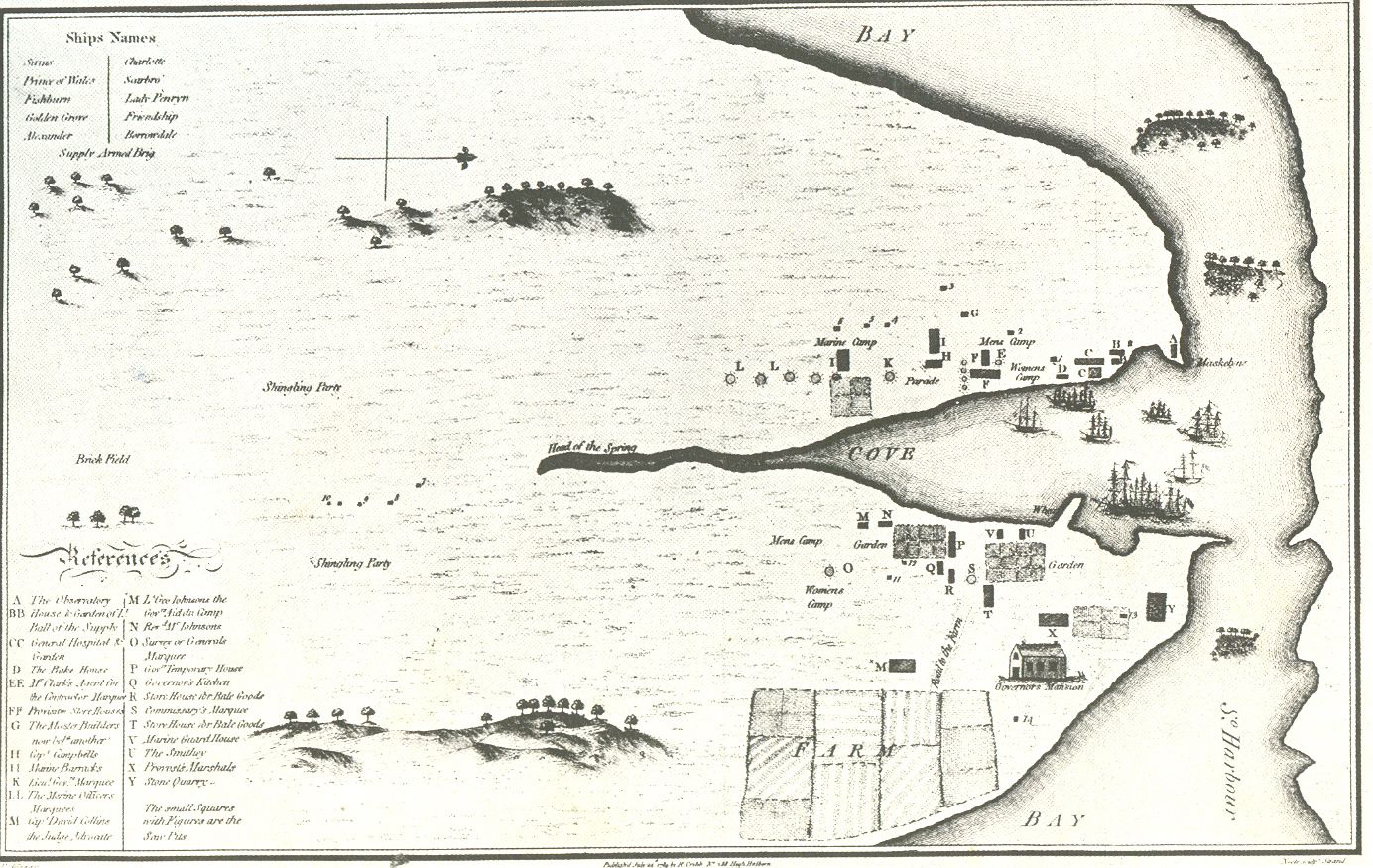
Cove 就是 Sydney Cove.也就是现在的环形码头那里. 这幅地图标示为右面是北,上面是西,当时的北悉尼海岸线画得很不准确,也没有任何文字地点标识,后来的悉尼港口大桥就将海湾上面西角的岩石区与北岸连接,悉尼歌剧院在海湾下面的那个东角上,FARM是现在的皇家植物园所在地.悉尼湾的河道(Head of spring)变成暗渠,一条名叫Bridge(桥)的街道对应原先海湾河道上过桥的马路。
A map of Sydney from 1789 done by a transported convict. very old - hence public domain
Licensing
|
This work is in the public domain in its country of origin and other countries and areas where the copyright term is the author's life plus 70 years or fewer. | |
| This file has been identified as being free of known restrictions under copyright law, including all related and neighboring rights. | |
File history
Click on a date/time to view the file as it appeared at that time.
| Date/Time | Thumbnail | Dimensions | User | Comment | |
|---|---|---|---|---|---|
| current | 09:21, 27 October 2005 | | 1,384 × 875 (310 KB) | Roke~commonswiki | A map of Sydney from 1789 done by a transported convict. very old - hence public domain Category: Sydney |
File usage
The following pages on the English Wikipedia use this file (pages on other projects are not listed):
Global file usage
The following other wikis use this file:
- Usage on af.wikipedia.org
- Usage on als.wikipedia.org
- Usage on ast.wikipedia.org
- Usage on ba.wikipedia.org
- Usage on ca.wikipedia.org
- Usage on cs.wikipedia.org
- Usage on da.wikipedia.org
- Usage on de.wikipedia.org
- Usage on el.wikipedia.org
- Usage on en.wikiversity.org
- Usage on eo.wikipedia.org
- Usage on es.wikipedia.org
- Usage on frr.wikipedia.org
- Usage on fr.wikipedia.org
- Usage on gl.wikipedia.org
- Usage on he.wikipedia.org
- Usage on hsb.wikipedia.org
- Usage on id.wikipedia.org
- Usage on it.wikipedia.org
- Usage on ja.wikipedia.org
- Usage on li.wikipedia.org
- Usage on lv.wikipedia.org
- Usage on ms.wikipedia.org
- Sejarah Sydney
- Sejarah Australia (1788–1850)
- Paddington, New South Wales
- Wikipedia:Bengkel/Rencana contoh/Sejarah Australia (1788–1850)
- Wikipedia:Bengkel/Malaysia/2024/10-09/Tatabahasa/Sejarah Australia (1788–1850)
- Wikipedia:Bengkel/Malaysia/2024/10-09/Rujukan/Sejarah Australia (1788–1850)
- Wikipedia:Bengkel/Malaysia/2024/10-09/Format/Sejarah Australia (1788–1850)
- Usage on nds.wikipedia.org
- Usage on nn.wikipedia.org
- Usage on no.wikipedia.org
- Usage on ru.wikipedia.org
- Usage on zh.wikipedia.org