
File:Upper volta map with rivers.PNG
Size of this preview: 800 × 560 pixels. Other resolutions: 320 × 224 pixels | 640 × 448 pixels | 1,000 × 700 pixels.
Original file (1,000 × 700 pixels, file size: 250 KB, MIME type: image/png)
| This is a file from the Wikimedia Commons. Information from its description page there is shown below. Commons is a freely licensed media file repository. You can help. |
Summary
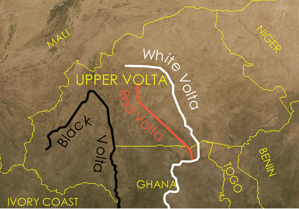
Map showing Upper volta and the red black and white volta rivers
The satellite image is a public domain image from NASA world wind, the other details were added on in Corel Painter IX.
Licensing

|
Permission is granted to copy, distribute and/or modify this document under the terms of the GNU Free Documentation License, Version 1.2 or any later version published by the Free Software Foundation; with no Invariant Sections, no Front-Cover Texts, and no Back-Cover Texts. A copy of the license is included in the section entitled GNU Free Documentation License. |
| This file is licensed under the Creative Commons Attribution-Share Alike 3.0 Unported license. | ||
| ||
| This licensing tag was added to this file as part of the GFDL licensing update. |
File history
Click on a date/time to view the file as it appeared at that time.
| Date/Time | Thumbnail | Dimensions | User | Comment | |
|---|---|---|---|---|---|
| current | 11:03, 28 April 2006 | | 1,000 × 700 (250 KB) | Roke~commonswiki | smaller file size |
| 11:00, 28 April 2006 |  | 1,000 × 700 (421 KB) | Roke~commonswiki | curved text, surrounding countries | |
| 05:26, 28 April 2006 |  | 1,000 × 697 (283 KB) | Roke~commonswiki | smaller file size | |
| 10:31, 23 March 2006 |  | 1,000 × 697 (1.33 MB) | Roke~commonswiki | Map showing Upper volta and the red black and white volta rivers Category: Burkina Faso The satellite image is a public domain image from NASA world wind, the other details were added on in Corel Painter IX. |
File usage
The following 2 pages use this file:
Global file usage
The following other wikis use this file:
- Usage on ar.wikipedia.org
- Usage on azb.wikipedia.org
- Usage on ca.wikipedia.org
- Usage on da.wikipedia.org
- Usage on he.wikipedia.org
- Usage on hi.wikipedia.org
- Usage on id.wikipedia.org
- Usage on pt.wikipedia.org
- Usage on ro.wikipedia.org
- Usage on simple.wikipedia.org
- Usage on sr.wikipedia.org
- Usage on sw.wikipedia.org
- Usage on vi.wikipedia.org
- Usage on yo.wikipedia.org