
File:USGS Alto 1909 sfc01578.jpg

Size of this preview: 405 × 599 pixels. Other resolutions: 162 × 240 pixels | 325 × 480 pixels | 519 × 768 pixels | 693 × 1,024 pixels | 1,385 × 2,048 pixels | 2,976 × 4,399 pixels.
Original file (2,976 × 4,399 pixels, file size: 7.66 MB, MIME type: image/jpeg)
| This is a file from the Wikimedia Commons. Information from its description page there is shown below. Commons is a freely licensed media file repository. You can help. |
Summary
| Description |
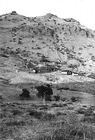
English: Alto mine, camp and mill, looking northeast, tunnel is at outcrop below the summit Santa Cruz County, Arizona. 1909. Plate 15 in U.S. Geological Survey. Bulletin 582. 1915. |
|||
| Date | ||||
| Source | http://libraryphoto.cr.usgs.gov/cgi-bin/show_picture.cgi?ID=ID.%20Schrader,%20F.C.%201578 | |||
| Author | USGS | |||
| Permission (Reusing this file) |
|
Licensing
This image is in the public domain in the United States because it only contains materials that originally came from the United States Geological Survey, an agency of the United States Department of the Interior. For more information, see the official USGS copyright policy.
|
File history
Click on a date/time to view the file as it appeared at that time.
| Date/Time | Thumbnail | Dimensions | User | Comment | |
|---|---|---|---|---|---|
| current | 02:59, 30 January 2013 | | 2,976 × 4,399 (7.66 MB) | Slick-o-bot | Bot: convert to a non-interlaced jpeg (see bug #17645) |
| 14:52, 7 August 2009 |  | 2,976 × 4,399 (6.94 MB) | Transity | == Summary == {{Information |Description={{en|1=Alto mine, camp and mill, mostly in SE ¬ , Sec. 12, looking northeast, tunnel is at outcrop below the summit Santa Cruz County, Arizona. 1909. Plate 15 in U.S. Geological Survey. Bulletin 582. 1915.}} |Sour |
File usage
The following page uses this file: