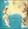
File:Topographical map Cape Peninsula and False Bay2.png
Appearance

Size of this preview: 578 × 600 pixels. Other resolutions: 231 × 240 pixels | 463 × 480 pixels | 740 × 768 pixels | 987 × 1,024 pixels | 2,349 × 2,437 pixels.
Original file (2,349 × 2,437 pixels, file size: 557 KB, MIME type: image/png)
File history
Click on a date/time to view the file as it appeared at that time.
| Date/Time | Thumbnail | Dimensions | User | Comment | |
|---|---|---|---|---|---|
| current | 15:41, 4 January 2010 |  | 2,349 × 2,437 (557 KB) | Pbsouthwood | slightly smaller file |
| 15:35, 4 January 2010 |  | 3,524 × 3,656 (949 KB) | Pbsouthwood | {{Information |Description={{en|1=Topographical map of the Cape Peninsula and False Bay including the Hottentot's Holland mountains to Hangklip and bathymetry, with dive site names.}} |Source={{own}} |Author=Pbsouthwood |Date=First pu |
File usage
The following 7 pages use this file:
- List of brown seaweeds of the Cape Peninsula and False Bay
- List of green seaweeds of the Cape Peninsula and False Bay
- List of marine invertebrates of the Cape Peninsula and False Bay
- List of marine vertebrates of the Cape Peninsula and False Bay
- List of red seaweeds of the Cape Peninsula and False Bay
- User:Pbsouthwood/Image catalogue 1
- User:Seascapeza/Sandbox
Global file usage
The following other wikis use this file:
- Usage on ca.wikipedia.org
- Usage on cs.wikipedia.org
- Usage on en.wikivoyage.org
- Usage on fr.wikipedia.org
- Usage on gl.wikipedia.org
- Usage on nl.wikipedia.org
- Usage on www.wikidata.org
