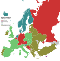
File:Territorial organization of European countries.svg
Appearance

Size of this PNG preview of this SVG file: 587 × 600 pixels. Other resolutions: 235 × 240 pixels | 470 × 480 pixels | 752 × 768 pixels | 1,002 × 1,024 pixels | 2,004 × 2,048 pixels | 593 × 606 pixels.
Original file (SVG file, nominally 593 × 606 pixels, file size: 601 KB)
File history
Click on a date/time to view the file as it appeared at that time.
| Date/Time | Thumbnail | Dimensions | User | Comment | |
|---|---|---|---|---|---|
| current | 16:12, 9 December 2022 |  | 593 × 606 (601 KB) | Iktsokh | Added countries (please correct in case of errors) |
| 06:44, 8 July 2021 |  | 593 × 606 (521 KB) | Reodorant | File uploaded using svgtranslate tool (https://svgtranslate.toolforge.org/). Added translation for ro. | |
| 16:52, 22 June 2021 |  | 593 × 606 (521 KB) | Sbb1413 | Added the Russian Fedration as a federal state as per its official name. | |
| 16:49, 22 June 2021 |  | 593 × 606 (521 KB) | Sbb1413 | The original map looks like a rasterified version of the SVG map. Therefore, re-vectorised. | |
| 17:56, 11 September 2018 |  | 2,000 × 2,044 (962 KB) | Hazbulator | Bosnia and Herzegovina is a federal state, not a confederal one. Confirmed by looking into the Constitution of Bosnia and Herzegovina. Sicne none of the two entities in Bosnia and Herzeogivna are soverign states, nor they have independence, they are entities, a special type of administrative division, applied in Bosnia and Herzegovina. Source: Constitutional Court of Bosnia and Herezovina, "Constitution of Bosnia and Herzegovina (English), http://www.ccbh.ba/, 1995. Link to source: http://www... | |
| 08:54, 28 April 2018 |  | 593 × 606 (709 KB) | Underlying lk | User created page with UploadWizard |
File usage
The following page uses this file:
Global file usage
The following other wikis use this file:
- Usage on bn.wikipedia.org
- Usage on es.wikipedia.org
- Usage on lmo.wikipedia.org
- Usage on ro.wikipedia.org
