
File:Sri Lankan Parliamentary Election 2010.png
Size of this preview: 380 × 599 pixels. Other resolutions: 152 × 240 pixels | 304 × 480 pixels | 648 × 1,022 pixels.
Original file (648 × 1,022 pixels, file size: 66 KB, MIME type: image/png)
| This is a file from the Wikimedia Commons. Information from its description page there is shown below. Commons is a freely licensed media file repository. You can help. |

|
This election map image could be re-created using vector graphics as an SVG file. This has several advantages; see Commons:Media for cleanup for more information. If an SVG form of this image is available, please upload it and afterwards replace this template with
{{vector version available|new image name}}.
It is recommended to name the SVG file “Sri Lankan Parliamentary Election 2010.svg”—then the template Vector version available (or Vva) does not need the new image name parameter. |
Summary
| Description |
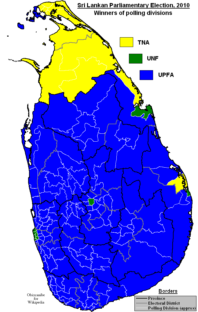
English: Map showing winners of polling divisions in the Sri Lankan parliamentary election of 2010. |
| Date | |
| Source | Own work. Used File:Sri Lanka divisions.png as template. Data taken from Department of Elections, Sri Lanka |
| Author | Obi2canibe |
Licensing
| I, the copyright holder of this work, release this work into the public domain. This applies worldwide. In some countries this may not be legally possible; if so: I grant anyone the right to use this work for any purpose, without any conditions, unless such conditions are required by law. |
File history
Click on a date/time to view the file as it appeared at that time.
| Date/Time | Thumbnail | Dimensions | User | Comment | |
|---|---|---|---|---|---|
| current | 18:27, 21 April 2010 | | 648 × 1,022 (66 KB) | Obi2canibe | Update Nawalapitiya & Trincomalee Category:Election maps of Sri Lanka |
| 19:01, 12 April 2010 |  | 648 × 1,022 (66 KB) | Obi2canibe | Update Chilaw & Ratnapura | |
| 22:12, 9 April 2010 |  | 648 × 1,022 (66 KB) | Obi2canibe | {{Information |Description={{en|1=Map showing winners of polling divisions in the Sri Lankan parliamentary election of 2010. Used File:Sri Lanka divisions.png as template.}} |Source={{own}} |Author=Obi2canibe |Date=2010-04-09 |Permissi |
File usage
The following pages on the English Wikipedia use this file (pages on other projects are not listed):
Global file usage
The following other wikis use this file:
- Usage on fr.wikipedia.org
- Usage on id.wikipedia.org
- Usage on mk.wikipedia.org
- Usage on pl.wikipedia.org
- Usage on pt.wikipedia.org
- Usage on si.wikipedia.org
- Usage on ta.wikipedia.org
- Usage on ta.wikinews.org