
File:Salt Creek Covered Bridge.jpg

Size of this preview: 800 × 559 pixels. Other resolutions: 320 × 224 pixels | 640 × 447 pixels | 1,024 × 715 pixels | 1,280 × 894 pixels | 2,560 × 1,788 pixels | 4,568 × 3,191 pixels.
Original file (4,568 × 3,191 pixels, file size: 2.14 MB, MIME type: image/jpeg)
| This is a file from the Wikimedia Commons. Information from its description page there is shown below. Commons is a freely licensed media file repository. You can help. |
|
This is an image of a place or building that is listed on the National Register of Historic Places in the United States of America. Its reference number is 74001587. |
| Camera location | | View this and other nearby images on: OpenStreetMap |
|---|
| Description |
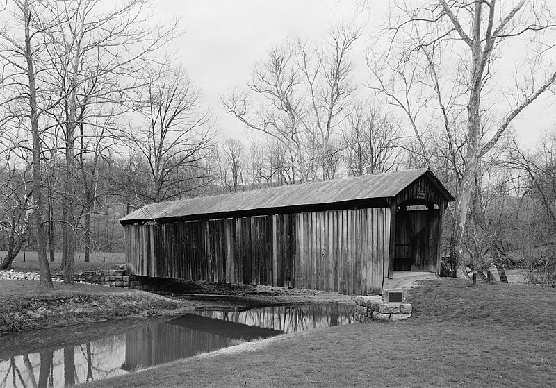
English: Eastern side of the Salt Creek Covered Bridge, which spans Big Salt Creek northwest of Norwich in Perry Township, Muskingum County, Ohio, United States. Built in 1876, the Warren truss bridge is listed on the National Register of Historic Places. |
|||||||||||||||||||||||
| Date | ||||||||||||||||||||||||
| Source | Library of Congress, Prints and Photograph Division HAER: OH-127-3 | |||||||||||||||||||||||
| Author |
|
|||||||||||||||||||||||
| Permission (Reusing this file) |
|
|||||||||||||||||||||||
.jpg)

|
This image is available from the United States Library of Congress's Prints and Photographs division
under the digital ID hhh.oh1929. This tag does not indicate the copyright status of the attached work. A normal copyright tag is still required. See Commons:Licensing.
|
File history
Click on a date/time to view the file as it appeared at that time.
| Date/Time | Thumbnail | Dimensions | User | Comment | |
|---|---|---|---|---|---|
| current | 17:27, 14 April 2009 | | 4,568 × 3,191 (2.14 MB) | Cropbot | upload cropped version, operated by User:Finavon. Summary: border cropped |
| 15:05, 14 April 2009 |  | 5,099 × 3,664 (2.35 MB) | Nyttend | {{Location|39|59|55|N|81|50|24|W}} {{Information |Description={{en|Eastern side of the {{w|Salt Creek Covered Bridge}}, which spans Big Salt Creek northwest of {{w|Norwich, Ohio|Norwich}} in {{w|Perry Township, Muskingum County, Ohio|Perry Township}}, {{w |
File usage
The following pages on the English Wikipedia use this file (pages on other projects are not listed):
Global file usage
The following other wikis use this file:
- Usage on es.wikipedia.org
- Usage on eu.wikipedia.org
- Usage on fa.wikipedia.org
- Usage on pt.wikipedia.org
- Usage on ur.wikipedia.org
- Usage on vi.wikipedia.org
- Usage on www.wikidata.org
- Usage on zh.wikipedia.org