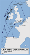
File:Routes of the Spanish Armada-es.svg
Appearance

Size of this PNG preview of this SVG file: 327 × 599 pixels. Other resolutions: 131 × 240 pixels | 262 × 480 pixels | 419 × 768 pixels | 559 × 1,024 pixels | 1,118 × 2,048 pixels | 411 × 753 pixels.
Original file (SVG file, nominally 411 × 753 pixels, file size: 172 KB)
File history
Click on a date/time to view the file as it appeared at that time.
| Date/Time | Thumbnail | Dimensions | User | Comment | |
|---|---|---|---|---|---|
| current | 13:13, 20 October 2008 |  | 411 × 753 (172 KB) | Redtony | {{Information |Description=Map of the route taken by the Spanish Armada. Source: [http://www.dean.usma.edu/history/web03/atlases/dawn_modern_warfare/dawn%20modern%20warfare%20maps/routes_armada.gif History Department of the United States Military Aca |
File usage
The following 3 pages use this file:
Global file usage
The following other wikis use this file:
- Usage on bg.wikipedia.org
- Usage on ca.wikipedia.org
- Usage on es.wikipedia.org
- Usage on fr.wikipedia.org
- Usage on gl.wikipedia.org
- Usage on lij.wikipedia.org


