
File:Rothenburg ob der Tauber Bomben Zerstörung Weltkrieg 1945.jpg
No higher resolution available.
Rothenburg_ob_der_Tauber_Bomben_Zerstörung_Weltkrieg_1945.jpg (799 × 576 pixels, file size: 92 KB, MIME type: image/jpeg)
| This is a file from the Wikimedia Commons. Information from its description page there is shown below. Commons is a freely licensed media file repository. You can help. |
Summary
| Camera location | | View this and other nearby images on: OpenStreetMap |
|---|
| Description |
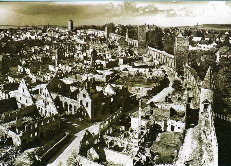
English: Historical photo (ca. 1945) of the bombed old town of Rothenburg ob der Tauber, Bavaria, Germany. March 31, Allied bombs were dropped over Rothenburg by 16 planes, killing 39 people and destroying 306 houses, six public buildings, nine watchtowers, and over 2,000 feet (610 m) of the medieval town wall. Most of the buildings were reconstructed accurately. Location of the photographer : Faulturm
Deutsch: Historisches Foto (ca. 1945) der zerbombten Altstadt von Rothenburg ob der Tauber, Bayern, Deutschland. Am 31. März wurden von 16 Flugzeugen alliierte Bomben abgeworfen, die 39 Menschen töteten, 306 Häuser zerstörten (darunter 6 öffentliche Gebäude), zudem 9 Türme und über 610m der mittelalterlichen Stadtmauer. Die meisten Bauten wurden in der Folgezeit nach dem Krieg sorgfältig rekonstruiert. Aufnahmeort: Faulturm |
| Date | circa 1945 |
| Source | Photobucket - Jimmy001 |
| Author | Unknown author |
Licensing
|
This work is in the public domain in its country of origin and other countries and areas where the copyright term is the author's life plus 70 years or fewer. | |
| This file has been identified as being free of known restrictions under copyright law, including all related and neighboring rights. | |
File history
Click on a date/time to view the file as it appeared at that time.
| Date/Time | Thumbnail | Dimensions | User | Comment | |
|---|---|---|---|---|---|
| current | 14:47, 1 March 2010 | | 799 × 576 (92 KB) | Horst-schlaemma | {{Information |Description={{en|1=Historical photo (ca. 1945) of the bombed old town of Rothenburg ob der Tauber, Bavaria, Germany. March 31, Allied bombs were dropped over Rothenburg by 16 planes, killing 39 people and destroying 306 houses, six public b |
File usage
The following pages on the English Wikipedia use this file (pages on other projects are not listed):
Global file usage
The following other wikis use this file:
- Usage on ba.wikipedia.org
- Usage on de.wikipedia.org
- Usage on es.wikipedia.org
- Usage on fy.wikipedia.org
- Usage on ja.wikipedia.org
- Usage on ky.wikipedia.org
- Usage on nl.wikipedia.org
- Usage on ru.wikipedia.org
- Usage on tr.wikipedia.org