
File:Qatar municipalities map after 2004 reorganization english.svg

Size of this PNG preview of this SVG file: 344 × 600 pixels. Other resolutions: 137 × 240 pixels | 275 × 480 pixels | 440 × 768 pixels | 587 × 1,024 pixels | 1,175 × 2,048 pixels | 459 × 800 pixels.
Original file (SVG file, nominally 459 × 800 pixels, file size: 134 KB)
| This is a file from the Wikimedia Commons. Information from its description page there is shown below. Commons is a freely licensed media file repository. You can help. |
Summary
| Description |
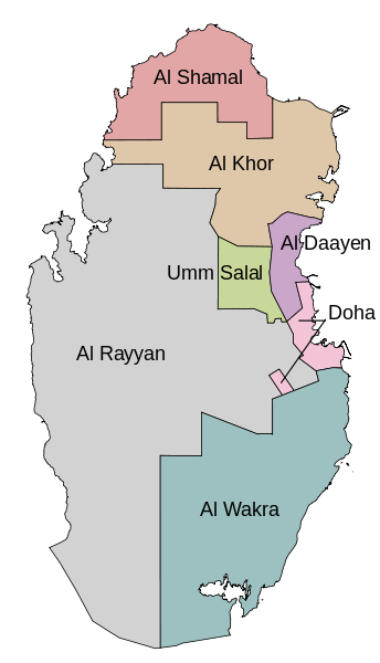
English: Map of the Qatar municipalities after the 2004 reorganization. In English. |
| Date | |
| Source | Self-made using OpenJUMP and Inkscape. Based on Explore Qatar GIS. |
| Author | Bamyers99 |
| Other versions |
|

Licensing
I, the copyright holder of this work, hereby publish it under the following license:
| This file is made available under the Creative Commons CC0 1.0 Universal Public Domain Dedication. | |
| The person who associated a work with this deed has dedicated the work to the public domain by waiving all of their rights to the work worldwide under copyright law, including all related and neighboring rights, to the extent allowed by law. You can copy, modify, distribute and perform the work, even for commercial purposes, all without asking permission.
|
File history
Click on a date/time to view the file as it appeared at that time.
| Date/Time | Thumbnail | Dimensions | User | Comment | |
|---|---|---|---|---|---|
| current | 21:43, 22 December 2011 | | 459 × 800 (134 KB) | Bamyers99 | {{Information |Description ={{en|1=Map of the Qatar municipalities after the 2004 reorganization. In English.}} |Source =Self-made using OpenJUMP and Inkscape. Based on [http://www.gisqatar.org.qa/ExploreEN/ Explore Qatar GIS]. |Author |
File usage
No pages on the English Wikipedia use this file (pages on other projects are not listed).
Global file usage
The following other wikis use this file:
- Usage on ace.wikipedia.org
- Usage on az.wikipedia.org
- Usage on it.wikipedia.org
- Usage on lez.wikipedia.org
- Usage on mzn.wikipedia.org
- Usage on nn.wikipedia.org
- Usage on no.wikipedia.org
- Usage on uk.wikipedia.org
- Usage on xmf.wikipedia.org