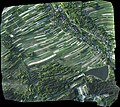
File:Pteryx UAV - Ortophoto 4.5km2.jpg
Appearance

Size of this preview: 675 × 600 pixels. Other resolutions: 270 × 240 pixels | 540 × 480 pixels | 864 × 768 pixels | 1,152 × 1,024 pixels.
Original file (1,152 × 1,024 pixels, file size: 522 KB, MIME type: image/jpeg)
File history
Click on a date/time to view the file as it appeared at that time.
| Date/Time | Thumbnail | Dimensions | User | Comment | |
|---|---|---|---|---|---|
| current | 01:53, 13 October 2011 |  | 1,152 × 1,024 (522 KB) | Kbosak | {{Information |Description ={{en|1=An example of ortophotomap assembled from 750 photos taken during a flight of small UAV. 4.5km2 surface, 11.1cm/pixel resolution, 300m flight altitude, 1h flight duration. Note high contrast compared to full scale air |
File usage
The following page uses this file:
