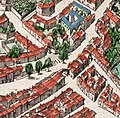
File:Portail Magnanen on 17th century Avignon map.jpg
Appearance
Portail_Magnanen_on_17th_century_Avignon_map.jpg (452 × 443 pixels, file size: 116 KB, MIME type: image/jpeg)
File history
Click on a date/time to view the file as it appeared at that time.
| Date/Time | Thumbnail | Dimensions | User | Comment | |
|---|---|---|---|---|---|
| current | 14:51, 3 July 2020 |  | 452 × 443 (116 KB) | Aa77zz | {{Information |description=Detail from a 17th century map of Avignon in the Atlas Van Loon showing the two gates of the Portail Magnanen that once formed part of the 13th century double city walls. Although published in 1663 this map is a careful copy of an earlier map on 8 plates that was published in 1618. The detail shows the junction between the Rue des Lices running across and the Rue du Portail Magnanen. Also depicted is a small bridge over what had originally be... |
File usage
The following page uses this file:


