
File:Pc-map.jpg
No higher resolution available.
Pc-map.jpg (351 × 377 pixels, file size: 42 KB, MIME type: image/jpeg)
| This is a file from the Wikimedia Commons. Information from its description page there is shown below. Commons is a freely licensed media file repository. You can help. |
| Description |
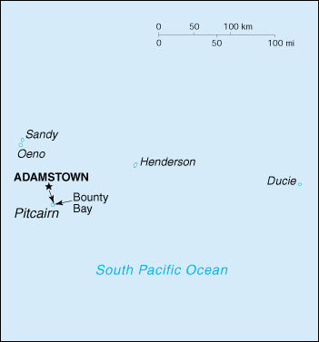
map of Pitcairn Islands (CIA Factbook) Polski: Kolonia Pitcairn z zaznaczoną wyspą Ducie |
|||
| Date | ||||
| Source | CIA World Factbook, PCL Map Collection | |||
| Author | User Jheijmans on en.wikipedia | |||
| Permission (Reusing this file) |
|
|||
| Other versions |
Originally from en.wikipedia; description page is (was) here * 03:29, 4 September 2002 [[:en:User:Jheijmans|Jheijmans]] 351×377 (42,825 bytes) <span class="comment">(map of Pitcairn Islands (CIA Factbook))</span> |

(Uploaded using CommonsHelper or PushForCommons)
File history
Click on a date/time to view the file as it appeared at that time.
| Date/Time | Thumbnail | Dimensions | User | Comment | |
|---|---|---|---|---|---|
| current | 19:47, 31 October 2005 | | 351 × 377 (42 KB) | Reytan | map of Pitcairn Islands (CIA Factbook) {{PD-USGov-CIA-WF}} (From W:en:) |
File usage
No pages on the English Wikipedia use this file (pages on other projects are not listed).
Global file usage
The following other wikis use this file:
- Usage on ast.wikipedia.org
- Usage on eo.wikipedia.org
- Usage on es.wikipedia.org
- Usage on ext.wikipedia.org
- Usage on fy.wikipedia.org
- Usage on mt.wikipedia.org
- Usage on pl.wikipedia.org
- Usage on ru.wikipedia.org