
File:Oman admin divisions.png
Size of this preview: 474 × 599 pixels. Other resolutions: 190 × 240 pixels | 380 × 480 pixels | 813 × 1,027 pixels.
Original file (813 × 1,027 pixels, file size: 29 KB, MIME type: image/png)
| This is a file from the Wikimedia Commons. Information from its description page there is shown below. Commons is a freely licensed media file repository. You can help. |
Summary
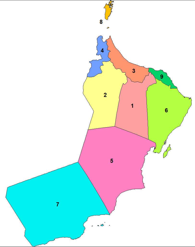
| Description | Map of the 1st level administrative divisions (governorates and regions) of Oman. Includes the newest governorate of Al Buraimi. Created by Rarelibra 14:03, 25 February 2008 (UTC) for public domain use. |
| Date | 25 February 2008 (original upload date) |
| Source | No machine-readable source provided. Own work assumed (based on copyright claims). |
| Author | No machine-readable author provided. Rarelibra assumed (based on copyright claims). |
Licensing
| I, the copyright holder of this work, release this work into the public domain. This applies worldwide. In some countries this may not be legally possible; if so: I grant anyone the right to use this work for any purpose, without any conditions, unless such conditions are required by law. |
File history
Click on a date/time to view the file as it appeared at that time.
| Date/Time | Thumbnail | Dimensions | User | Comment | |
|---|---|---|---|---|---|
| current | 14:03, 25 February 2008 | | 813 × 1,027 (29 KB) | Rarelibra | Map of the 1st level administrative divisions (governorates and regions) of Oman. Includes the newest governorate of Al Buraimi. Created by ~~~~ for public domain use. |
File usage
The following 4 pages use this file:
Global file usage
The following other wikis use this file:
- Usage on ace.wikipedia.org
- Usage on ar.wikipedia.org
- Usage on awa.wikipedia.org
- Usage on ba.wikipedia.org
- Usage on bn.wikipedia.org
- Usage on ca.wikipedia.org
- Usage on de.wikipedia.org
- Usage on es.wikipedia.org
- Usage on eu.wikipedia.org
- Usage on fa.wikipedia.org
- Usage on fr.wikipedia.org
- Usage on fr.wikivoyage.org
- Usage on gu.wikipedia.org
- Usage on hi.wikipedia.org
- Usage on ka.wikipedia.org
- Usage on ko.wikipedia.org
- Usage on mai.wikipedia.org
- Usage on mt.wikipedia.org
- Usage on mzn.wikipedia.org
- Usage on new.wikipedia.org
- Usage on nl.wikipedia.org
- Usage on nn.wikipedia.org
- Usage on ru.wikipedia.org
- Usage on sco.wikipedia.org
- Usage on sk.wikipedia.org
- Usage on sr.wikipedia.org
- Usage on sv.wikipedia.org
- Usage on th.wikipedia.org
- Usage on tr.wikipedia.org
- Usage on uk.wikipedia.org
- Usage on vi.wikipedia.org
- Usage on xmf.wikipedia.org
- Usage on zh.wikipedia.org