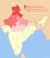
File:North India Zonal Map 14July2013.png
Appearance
North_India_Zonal_Map_14July2013.png (514 × 600 pixels, file size: 167 KB, MIME type: image/png)
File history
Click on a date/time to view the file as it appeared at that time.
| Date/Time | Thumbnail | Dimensions | User | Comment | |
|---|---|---|---|---|---|
| current | 02:34, 29 July 2013 |  | 514 × 600 (167 KB) | Hunnjazal | Reverting to *official* Govt of India definition based map - please do not hijack this! |
| 05:16, 23 July 2013 |  | 514 × 600 (160 KB) | BijoyChakrabarty | perfect destination of north india | |
| 18:49, 14 July 2013 |  | 514 × 600 (167 KB) | Hunnjazal | User created page with UploadWizard |
File usage
The following page uses this file:
Global file usage
The following other wikis use this file:
- Usage on dty.wikipedia.org
- Usage on es.wikipedia.org
- Usage on fa.wikipedia.org
- Usage on fr.wikipedia.org
- Usage on ja.wikipedia.org
- Usage on mr.wikipedia.org
- Usage on ms.wikipedia.org
- Usage on ne.wikipedia.org
- Usage on nn.wikipedia.org
- Usage on sat.wikipedia.org
- Usage on sa.wikipedia.org
- Usage on sd.wikipedia.org
- Usage on si.wikipedia.org
- Usage on th.wikipedia.org
- Usage on vi.wikipedia.org
- Usage on xmf.wikipedia.org

