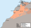
File:Morocco - Linguistic map.png
Appearance

Size of this preview: 650 × 599 pixels. Other resolutions: 260 × 240 pixels | 521 × 480 pixels | 652 × 601 pixels.
Original file (652 × 601 pixels, file size: 19 KB, MIME type: image/png)
File history
Click on a date/time to view the file as it appeared at that time.
| Date/Time | Thumbnail | Dimensions | User | Comment | |
|---|---|---|---|---|---|
| current | 09:19, 10 December 2019 |  | 652 × 601 (19 KB) | Omar-toons | Mod. Arabic-speaking areas Bhalil + Fechtala + More precise limits for Warayn & Seghrouchen |
| 04:12, 20 November 2013 |  | 652 × 601 (22 KB) | Omar-toons | Corr. Essaouira's location | |
| 03:32, 15 December 2012 |  | 652 × 601 (22 KB) | Omar-toons | {{Information |Description={{en|Linguistic map of Morocco}} |Source= Own made map |Date={{Original upload date|2012-07-18}}<br/> ({{Original upload date|2012-07-19}}) |Author=Omar-Toons. Original uploader was {{user at project|O... |
File usage
The following 3 pages use this file:
Global file usage
The following other wikis use this file:
- Usage on ar.wikipedia.org
- Usage on ary.wikipedia.org
- Usage on arz.wikipedia.org
- Usage on ca.wikipedia.org
- Usage on da.wikipedia.org
- Usage on es.wikipedia.org
- Usage on fr.wikipedia.org
- Usage on io.wikipedia.org
- Usage on it.wikipedia.org
- Usage on ko.wikipedia.org
- Usage on mt.wikipedia.org
- Usage on nl.wikipedia.org
- Usage on no.wikipedia.org
- Usage on shi.wikipedia.org
- Usage on simple.wikipedia.org
- Usage on si.wikipedia.org
- Usage on tr.wikipedia.org
- Usage on tum.wikipedia.org
- Usage on ur.wikipedia.org


