
File:MiG Alley Map.JPG
No higher resolution available.
MiG_Alley_Map.JPG (348 × 375 pixels, file size: 52 KB, MIME type: image/jpeg)
| This is a file from the Wikimedia Commons. Information from its description page there is shown below. Commons is a freely licensed media file repository. You can help. |
Summary

|
File:MiG Alley Map (en).svg is a vector version of this file. It should be used in place of this JPG file when not inferior.
File:MiG Alley Map.JPG → File:MiG Alley Map (en).svg
For more information, see Help:SVG. |
.svg) |
| Description |
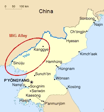
Deutsch: Das Gebiet an der chinesisch-nordkoreanischen Grenze, das während des Koreakrieges (1950-53) als "MiG Alley" berühmt wurde.
English: The area called "MiG Alley" during the Korean War (1950-53) on the Chinese-North Korean border. |
| Date | 01.06.2006 |
| Source | Own work based on CIA Factbook map on North Korea |
| Author | Triggerhappy |
| Other versions |
Chinese: Russian: Russian: |
Licensing
| I, the copyright holder of this work, release this work into the public domain. This applies worldwide. In some countries this may not be legally possible; if so: I grant anyone the right to use this work for any purpose, without any conditions, unless such conditions are required by law. |
File history
Click on a date/time to view the file as it appeared at that time.
| Date/Time | Thumbnail | Dimensions | User | Comment | |
|---|---|---|---|---|---|
| current | 20:09, 27 January 2012 | | 348 × 375 (52 KB) | Hohum | Cleanup |
| 17:27, 1 June 2006 |  | 348 × 375 (21 KB) | Triggerhappy | {{Information |Description=*'''de:''' Das Gebiet an der chinesisch-nordkoreanischen Grenze, das während des Koreakrieges (1950-53) als "MiG Alley" berühmt wurde. *'''en:''' The area called "MiG Alley" during the Korean War (1950-53) on the chinese-north |
File usage
No pages on the English Wikipedia use this file (pages on other projects are not listed).
Global file usage
The following other wikis use this file:
- Usage on zh.wikipedia.org