
File:Map of movement of federal troops and location of union and nonunion fighting during Blair Mountain Battle.png
Size of this preview: 683 × 599 pixels. Other resolutions: 274 × 240 pixels | 547 × 480 pixels | 875 × 768 pixels | 1,167 × 1,024 pixels | 1,500 × 1,316 pixels.
Original file (1,500 × 1,316 pixels, file size: 73 KB, MIME type: image/png)
| This is a file from the Wikimedia Commons. Information from its description page there is shown below. Commons is a freely licensed media file repository. You can help. |
Summary
| Description |
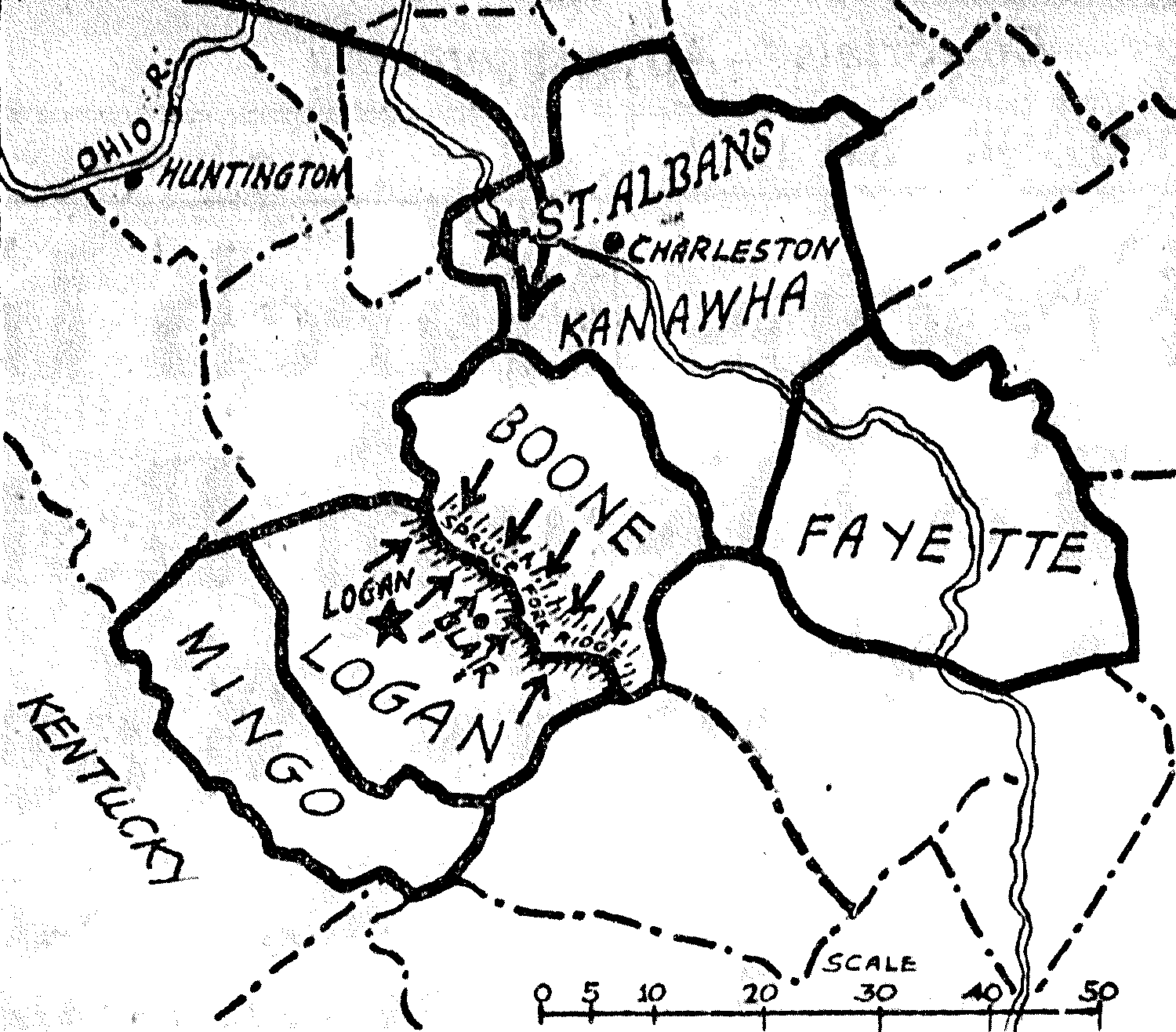
English: Map of the movement of federal troops arriving in West Virginia during the Battle of Blair Mountain. Also the location of union and nonunion fighters is indicated. The long arrow is the path of federal troops with their base being St. Albans. The short arrow in Logan are the nonunion fighters with their base being in Logan. |
| Date | |
| Source |
New-York tribune. (New York [N.Y.]), 03 Sept. 1921. http://chroniclingamerica.loc.gov/lccn/sn83030214/1921-09-03/ed-1/seq-2/ |
| Author | New York Tribune |
Licensing
This work is in the public domain in the United States because it was published (or registered with the U.S. Copyright Office) before January 1, 1929.
Public domain works must be out of copyright in both the United States and in the source country of the work in order to be hosted on the Commons. If the work is not a U.S. work, the file must have an additional copyright tag indicating the copyright status in the source country.
Note: This tag should not be used for sound recordings. |
File history
Click on a date/time to view the file as it appeared at that time.
| Date/Time | Thumbnail | Dimensions | User | Comment | |
|---|---|---|---|---|---|
| current | 10:35, 22 December 2018 | | 1,500 × 1,316 (73 KB) | Guest2625 | monochrome |
| 15:42, 20 December 2018 |  | 1,500 × 1,316 (947 KB) | Guest2625 | User created page with UploadWizard |
File usage
The following pages on the English Wikipedia use this file (pages on other projects are not listed):
Global file usage
The following other wikis use this file:
- Usage on de.wikipedia.org
- Usage on fa.wikipedia.org