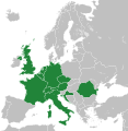
File:Map of areas affected by 2021 European floods.svg
Appearance

Size of this PNG preview of this SVG file: 587 × 600 pixels. Other resolutions: 235 × 240 pixels | 470 × 480 pixels | 752 × 768 pixels | 1,002 × 1,024 pixels | 2,004 × 2,048 pixels | 593 × 606 pixels.
Original file (SVG file, nominally 593 × 606 pixels, file size: 695 KB)
File history
Click on a date/time to view the file as it appeared at that time.
| Date/Time | Thumbnail | Dimensions | User | Comment | |
|---|---|---|---|---|---|
| current | 10:01, 27 December 2022 |  | 593 × 606 (695 KB) | Iktsokh | Correction of borders |
| 08:57, 22 July 2021 |  | 593 × 606 (692 KB) | Isochrone | update | |
| 14:12, 18 July 2021 |  | 593 × 606 (698 KB) | GPinkerton | Re-add France because there were also floods in France ([https://wiki.riteme.site/w/index.php?title=2021_European_floods&oldid=1034207380#France]). A more useful map would be by regions, there's no reason Sardinia, most of Great Britain, Northern Ireland, etc need to be here ... | |
| 09:44, 18 July 2021 |  | 593 × 606 (692 KB) | Jurryaany | Added Austria | |
| 18:28, 17 July 2021 |  | 593 × 606 (692 KB) | Isochrone | rm france | |
| 13:47, 17 July 2021 |  | 593 × 606 (692 KB) | Isochrone | better colour | |
| 13:40, 17 July 2021 |  | 593 × 606 (692 KB) | Isochrone | Uploaded own work with UploadWizard |
File usage
No pages on the English Wikipedia use this file (pages on other projects are not listed).
Global file usage
The following other wikis use this file:
- Usage on fr.wikipedia.org
- Usage on ja.wikipedia.org
- Usage on ne.wikipedia.org
- Usage on pl.wikipedia.org
- Usage on pt.wikipedia.org
- Usage on ro.wikipedia.org
- Usage on simple.wikipedia.org
- Usage on tr.wikipedia.org
