File:Map of Porlock Stone Circle.jpg
Appearance

Size of this preview: 719 × 599 pixels. Other resolutions: 288 × 240 pixels | 576 × 480 pixels | 921 × 768 pixels | 1,228 × 1,024 pixels | 2,442 × 2,036 pixels.
Original file (2,442 × 2,036 pixels, file size: 263 KB, MIME type: image/jpeg)
File history
Click on a date/time to view the file as it appeared at that time.
| Date/Time | Thumbnail | Dimensions | User | Comment | |
|---|---|---|---|---|---|
| current | 21:05, 31 December 2017 |  | 2,442 × 2,036 (263 KB) | Midnightblueowl | Trimmed and tidied. |
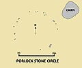
| 20:46, 31 December 2017 |  | 2,720 × 2,154 (264 KB) | Midnightblueowl | {{Information | Description = A simple plan of the Late Neolithic or Early Bronze Age Porlock Stone Circle in Somerset, England. Created by uploader based upon example by Gillings in "Excavation and Survey at Porlock Stone Circle and Row... |
File usage
The following page uses this file:
