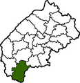
File:Map of Lviv Oblast highlighting Skole Raion.png
Appearance

Size of this preview: 575 × 600 pixels. Other resolutions: 230 × 240 pixels | 460 × 480 pixels | 736 × 768 pixels | 982 × 1,024 pixels | 1,987 × 2,072 pixels.
Original file (1,987 × 2,072 pixels, file size: 274 KB, MIME type: image/png)
File history
Click on a date/time to view the file as it appeared at that time.
| Date/Time | Thumbnail | Dimensions | User | Comment | |
|---|---|---|---|---|---|
| current | 16:44, 11 June 2015 |  | 1,987 × 2,072 (274 KB) | Andrew J.Kurbiko | upd |
| 19:33, 14 January 2007 |  | 368 × 380 (60 KB) | Olegzima | {{Image |Name= Skolevskyi-Raion |Description= map |Author= Olegzima |Source= Olegzima |Date= Jan 2007 |Licensing= {{PD}} }} Category:Raions_of_Lviv_Oblast |
File usage
The following 2 pages use this file:
Global file usage
The following other wikis use this file:
- Usage on be-tarask.wikipedia.org
- Usage on cs.wikipedia.org
- Usage on de.wikipedia.org
- Usage on es.wikipedia.org
- Usage on hy.wikipedia.org
- Usage on ka.wikipedia.org
- Usage on lv.wikipedia.org
- Usage on ru.wikipedia.org
- Usage on sco.wikipedia.org
- Usage on uk.wikipedia.org
- Usage on uk.wikisource.org
- Usage on vi.wikipedia.org
- Usage on www.wikidata.org
- Usage on zh-min-nan.wikipedia.org
- Usage on zh.wikipedia.org
