
File:Map of British North Borneo, yellow area covered by the Philippine claim.PNG
No higher resolution available.
Map_of_British_North_Borneo,_yellow_area_covered_by_the_Philippine_claim.PNG (570 × 438 pixels, file size: 552 KB, MIME type: image/png)
| This is a file from the Wikimedia Commons. Information from its description page there is shown below. Commons is a freely licensed media file repository. You can help. |
| Description |
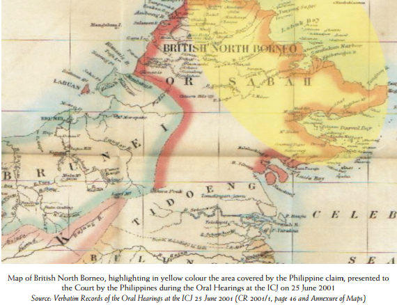
English: Map of British North Borneo, highlighting in yellow colour the area covered by the Philippine claim, presented to the Court by the Philippines during the Oral Hearings at the ICJ on 25 June 2001 Source: Verbatim Records of the Oral Hearings at the ICJ 25 June 2001 (CR 2001/1, page 46 and Annexure of Maps) |
|||||||
| Date | Map since 18th century (Presented by the Philippines to ICJ on 25 June 2001) | |||||||
| Source | Map of British North Borneo, highlighting in yellow colour the area covered by the Philippine claim, presented to the Court by the Philippines during the Oral Hearings at the ICJ on 25 June 2001 | |||||||
| Author | Unknown author | |||||||
| Permission (Reusing this file) |
|
|||||||

File history
Click on a date/time to view the file as it appeared at that time.
| Date/Time | Thumbnail | Dimensions | User | Comment | |
|---|---|---|---|---|---|
| current | 14:50, 16 May 2014 | | 570 × 438 (552 KB) | Muffin Wizard | {{Information |Description ={{en|1=Map of British North Borneo, highlighting in yellow colour the area covered by the Philippine claim, presented to the Court by the Philippines during the Oral Hearings at the ICJ on 25 June 2001 Source: Verbatim Re... |
File usage
The following pages on the English Wikipedia use this file (pages on other projects are not listed):
Global file usage
The following other wikis use this file:
- Usage on fr.wikipedia.org
- Usage on hy.wikipedia.org
- Usage on pt.wikipedia.org