
File:Lyubsha and Ladoga map.jpg

Size of this preview: 800 × 464 pixels. Other resolutions: 320 × 186 pixels | 640 × 371 pixels | 834 × 484 pixels.
Original file (834 × 484 pixels, file size: 103 KB, MIME type: image/jpeg)
| This is a file from the Wikimedia Commons. Information from its description page there is shown below. Commons is a freely licensed media file repository. You can help. |
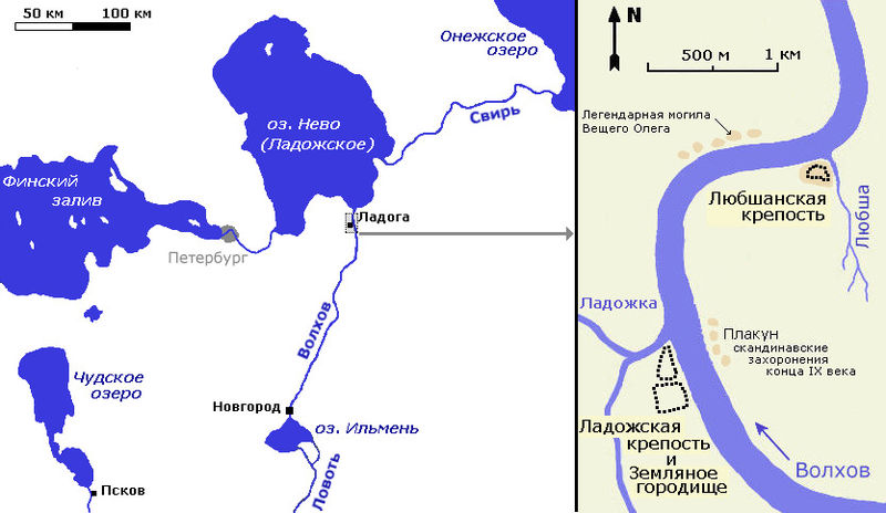
| Description | Map of ancient Rus' with detailed map for Ladoga and Lyubsha, first russian towns. Карта взаимного расположения Ладоги и Любшанской крепости нарисована на основе карты с [1] (статья А. Чернова) | ||
| Date | |||
| Source | Own work | ||
| Author | Vissarion | ||
| Permission (Reusing this file) |
|
File history
Click on a date/time to view the file as it appeared at that time.
| Date/Time | Thumbnail | Dimensions | User | Comment | |
|---|---|---|---|---|---|
| current | 14:36, 3 September 2007 | | 834 × 484 (103 KB) | Vissarion | {{Information |Description= Map of ancient Rus' with detailed map for Ladoga and Lyubsha, first russian towns. Карта взаимного расположения Ладоги и Любшанской крепости нарисована на осно� |
File usage
The following page uses this file:
Global file usage
The following other wikis use this file:
- Usage on fi.wikipedia.org
- Usage on ru.wikipedia.org