
File:Libya in the 1771 Bonne Map of the Mediterranean and the Maghreb or Barbary Coast - Geographicus - Barbarie-bonne-1771 (cropped).jpg

Size of this preview: 800 × 550 pixels. Other resolutions: 320 × 220 pixels | 640 × 440 pixels | 1,024 × 704 pixels | 1,280 × 880 pixels | 1,548 × 1,064 pixels.
Original file (1,548 × 1,064 pixels, file size: 395 KB, MIME type: image/jpeg)
| This is a file from the Wikimedia Commons. Information from its description page there is shown below. Commons is a freely licensed media file repository. You can help. |
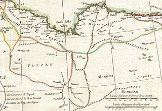
| Rigobert Bonne: Carte des Cotes de Barbarie ou Les Royaumes de Marco, de Fez, d'Alger, de Tunis, et de Tripoli avec les Pays Circonvoisins.
( |
|||||||||||||||||||||||
|---|---|---|---|---|---|---|---|---|---|---|---|---|---|---|---|---|---|---|---|---|---|---|---|
| Artist |
|
||||||||||||||||||||||
| Title |
Carte des Cotes de Barbarie ou Les Royaumes de Marco, de Fez, d'Alger, de Tunis, et de Tripoli avec les Pays Circonvoisins. |
||||||||||||||||||||||
| Description |
English: A beautiful example of Rigobert Bonne's decorative map of the Maghreb or Barbary Coast. Covers northwestern Africa and the western Mediterranean. This region, known since the days of Columbus as Tierra Firma, consists of the modern day nations of Tunisia, Libya, Algeria and Morocco. Offers excellent detail throughout showing mountains, rivers, national boundaries, cities, regions, and tribes. As Bonne was preparing this map, the Barbary Coast was a hotbed of piracy - much like the Somali coast today. The Barbary Pirates would attack trading ships passing through the narrow Gibraltar straits and western Mediterranean. Ships would be destroyed or appropriated, cargo sized, and the crews and passengers enslaved. By the early 19th century, piracy in this region had become so intense that the United States launched its first major naval offensive against Tripoli. The resultant 1805 Battle of Derne later inspired a portion of the lyrics of the Marines' Hymn , the shores of Tripoli. A large decorative title cartouche appears in the lower left quadrant. Drawn by R. Bonne in 1771 for issue as plate no. 30 in Jean Lattre's 1776 issue of the Atlas Moderne . |
||||||||||||||||||||||
| Date | 1771 (undated) | ||||||||||||||||||||||
| Dimensions | height: 13 in (33 cm); width: 17.5 in (44.4 cm) | ||||||||||||||||||||||
| Accession number |
Geographicus link: Barbarie-bonne-1771 |
||||||||||||||||||||||
| Source/Photographer |
Lattre, Jean, Atlas Moderne ou Collection de Cartes sur Toutes les Parties du Globe Terrestre, c. 1775.
|
||||||||||||||||||||||
| Permission (Reusing this file) |
|
||||||||||||||||||||||
| Other versions | |||||||||||||||||||||||

.jpg)
File history
Click on a date/time to view the file as it appeared at that time.
| Date/Time | Thumbnail | Dimensions | User | Comment | |
|---|---|---|---|---|---|
| current | 10:59, 27 September 2022 | | 1,548 × 1,064 (395 KB) | Onceinawhile | File:1771 Bonne Map of the Mediterranean and the Maghreb or Barbary Coast - Geographicus - Barbarie-bonne-1771.jpg cropped 56 % horizontally, 57 % vertically using CropTool with precise mode. |
File usage
The following pages on the English Wikipedia use this file (pages on other projects are not listed):
.jpg)