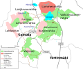
File:Kurjenrahka National Park-map.svg
Appearance

Size of this PNG preview of this SVG file: 547 × 459 pixels. Other resolutions: 286 × 240 pixels | 572 × 480 pixels | 915 × 768 pixels | 1,220 × 1,024 pixels | 2,441 × 2,048 pixels.
Original file (SVG file, nominally 547 × 459 pixels, file size: 60 KB)
File history
Click on a date/time to view the file as it appeared at that time.
| Date/Time | Thumbnail | Dimensions | User | Comment | |
|---|---|---|---|---|---|
| current | 08:33, 11 April 2018 |  | 547 × 459 (60 KB) | Albval | Added another missing trail |
| 08:10, 11 April 2018 |  | 547 × 459 (60 KB) | Albval | Added new trail | |
| 11:50, 18 November 2010 |  | 547 × 459 (60 KB) | Herra Maka | The colours of the restriction areas seem to have flipped in the legend by accident. | |
| 14:40, 25 August 2010 |  | 547 × 459 (54 KB) | Herra Maka | changing colors to less shocking ones | |
| 15:59, 23 August 2010 |  | 547 × 459 (51 KB) | Albval | Lake names larger and both lakes and their names darker for better visibility in thumbnails (thus nearly reverting my previous edit to them), moved some names to even more accurate places (though they're a bit big compared to the area they're marking) | |
| 15:26, 23 August 2010 |  | 547 × 459 (49 KB) | Herra Maka | Some roads made thicker, road number signs made opaque + adjusting some legend texts so that they shouldn't overlap with the borderline | |
| 10:26, 23 August 2010 |  | 547 × 459 (50 KB) | Albval | Smaller lake names, darker lake colour, village and other names moved to right places | |
| 09:57, 23 August 2010 |  | 547 × 459 (49 KB) | Herra Maka | Changing font from Arial to DejaVu Sans | |
| 09:07, 23 August 2010 |  | 547 × 459 (52 KB) | Herra Maka | {{Information |Description={{en|1=A map of the Kurjenrahka National Park in Finland Proper. The map is mainly based on [http://www.luontoon.fi/image.asp?Image=Att3195\webatt_20100708_144015_978504.gif this map] by Metsäha |
File usage
The following page uses this file:
Global file usage
The following other wikis use this file:
- Usage on arz.wikipedia.org
- Usage on az.wikipedia.org
- Usage on ceb.wikipedia.org
- Usage on en.wikivoyage.org
- Usage on fi.wikipedia.org
- Usage on fr.wikipedia.org
- Usage on uz.wikipedia.org
- Usage on www.wikidata.org

