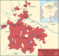
File:Karte Niederbayern-Landshut und Oberbayern.png
Appearance

Size of this preview: 631 × 599 pixels. Other resolutions: 253 × 240 pixels | 505 × 480 pixels | 808 × 768 pixels | 1,200 × 1,140 pixels.
Original file (1,200 × 1,140 pixels, file size: 361 KB, MIME type: image/png)
File history
Click on a date/time to view the file as it appeared at that time.
| Date/Time | Thumbnail | Dimensions | User | Comment | |
|---|---|---|---|---|---|
| current | 19:36, 13 May 2008 |  | 1,200 × 1,140 (361 KB) | Lencer | |
| 17:35, 13 April 2008 |  | 1,200 × 1,140 (358 KB) | Lencer | ||
| 15:58, 12 April 2008 |  | 1,200 × 1,140 (357 KB) | Lencer | {{Information |Description= |Source= |Date= |Author= |Permission= |other_versions= }} | |
| 12:57, 12 April 2008 |  | 1,200 × 1,192 (373 KB) | Lencer | {{Information| |Description=Karte des Herzogtums Niederbayern-Landshut und Oberbayern in seiner Ausdehnung von 1357 bis 1392 |Source=own work, used: * [http://www.datenmatrix.de/projekte/hdbg/karten/karten/vorschau/85.jpg Die vier Herzogtümer nach der Te |
File usage
The following page uses this file:
Global file usage
The following other wikis use this file:
- Usage on ar.wikipedia.org
- Usage on be.wikipedia.org
- Usage on bg.wikipedia.org
- Usage on cs.wikipedia.org
- Usage on de.wikipedia.org
- 1375
- Otto V. (Bayern)
- Stephan II. (Bayern)
- Bayerische Landesteilung von 1392
- Benutzer:Lencer
- Benutzer:Lencer/Galerie
- Wikipedia:Kartenwerkstatt/Archiv/2008-04
- Benutzer:Lencer/Unterseite
- Bayerische Landesteilung
- Geschichte der Stadt Burghausen
- Wikipedia:Kartenwerkstatt/Archiv/2011-02
- Bayerische Landesteilung von 1376
- Usage on es.wikipedia.org
- Usage on et.wikipedia.org
- Usage on fa.wikipedia.org
- Usage on he.wikipedia.org
- Usage on it.wikipedia.org
- Usage on ja.wikipedia.org
- Usage on ko.wikipedia.org
- Usage on mk.wikipedia.org
- Usage on pl.wikipedia.org
- Usage on pt.wikipedia.org
- Usage on ru.wikipedia.org
- Usage on th.wikipedia.org
- Usage on uk.wikipedia.org


