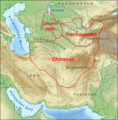
File:Karte Map Chorasan-Transoxanien-Choresmien.png
Appearance
Karte_Map_Chorasan-Transoxanien-Choresmien.png (589 × 597 pixels, file size: 550 KB, MIME type: image/png)
File history
Click on a date/time to view the file as it appeared at that time.
| Date/Time | Thumbnail | Dimensions | User | Comment | |
|---|---|---|---|---|---|
| current | 09:49, 25 April 2021 |  | 589 × 597 (550 KB) | Don-kun | Reverted to version as of 10:09, 5 May 2019 (UTC) map was according to the used sources; when you want to illustrate a different standpoint and design, upload a new file |
| 02:31, 25 April 2021 |  | 589 × 597 (611 KB) | Tunshi | Added Zabulistan and i forgot to upload the correct one before this | |
| 01:37, 25 April 2021 |  | 589 × 597 (559 KB) | Tunshi | Added Zabulistan | |
| 10:09, 5 May 2019 |  | 589 × 597 (550 KB) | Don-kun | Reverted to version as of 17:36, 3 October 2017 (UTC) no reason or source for changes given, different language | |
| 13:35, 4 May 2019 |  | 568 × 371 (351 KB) | Akhemen | Update and correct borders | |
| 17:36, 3 October 2017 |  | 589 × 597 (550 KB) | Don-kun | korrekturen entsprechend diskussion in Kartenwerkstatt. Nach: Putzger, Westermann, Brice, Kettermann; sowie Beschreibungen in den Artikeln zu den Regionen | |
| 11:51, 14 December 2010 |  | 592 × 600 (553 KB) | Lencer | namen statt buchstaben | |
| 10:07, 14 December 2010 |  | 592 × 600 (550 KB) | Lencer | {{Information |Description= Karte der historischen Regionen * A) Chorasan * B) Transoxanien * C) Choresmien <br>auf einer Kartengrundlage mit aktuellen Staatsgrenzen. |Source="own work", used: * [[:File:Relief Map of Middle East.jpg|Relief Map of Middle E |
File usage
No pages on the English Wikipedia use this file (pages on other projects are not listed).
Global file usage
The following other wikis use this file:
- Usage on an.wikipedia.org
- Usage on ba.wikipedia.org
- Usage on be.wikipedia.org
- Usage on bg.wikipedia.org
- Usage on bn.wikipedia.org
- Usage on ca.wikipedia.org
- Usage on cs.wikipedia.org
- Usage on da.wikipedia.org
- Usage on de.wikipedia.org
- Usage on el.wikipedia.org
- Usage on eo.wikipedia.org
- Usage on es.wikipedia.org
- Usage on et.wikipedia.org
- Usage on fa.wikipedia.org
- Usage on fi.wikipedia.org
- Usage on fr.wikipedia.org
- Usage on fy.wikipedia.org
- Usage on he.wikipedia.org
- Usage on hi.wikipedia.org
- Usage on hu.wikipedia.org
- Usage on it.wikipedia.org
- Usage on ja.wikipedia.org
- Usage on ka.wikipedia.org
- Usage on kk.wikipedia.org
- Usage on la.wikipedia.org
- Usage on mk.wikipedia.org
- Usage on mn.wikipedia.org
View more global usage of this file.


