File:Israel- geographical distribution of the main ethno-cultural communities.jpg

Original file (4,252 × 10,332 pixels, file size: 2.68 MB, MIME type: image/jpeg)
Summary
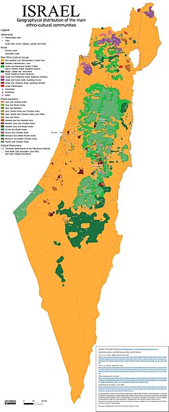
[edit]Copyright © 2022 Sergei Kondrashov (sergei.kondrashov@uq.edu.au). Calculated according to Israel 2008 Census and other Israel CBS datasets. Census geography is mostly represented by Statistical Areas (digital maps included in Israel CBS datasets). Some data is visualized at Municipality or Cadaster Block levels. Relative ethnic majority areas do not correspond to any political or administrative boundaries and are calculated using a set of different parameters. Classification, I used for building this map does not follow any Israeli classification. Although every effort has been made to ensure that the information contained in this map is accurate, the author can accept no liability for the consequence of any mistake or error in content or representation. This map is available under CC BY-NC-ND 4.0 unless otherwise noted.
| This work is licensed under the Creative Commons Attribution-ShareAlike 4.0 License. Attribution: Attribution-NoDerivatives |
File history
Click on a date/time to view the file as it appeared at that time.
| Date/Time | Thumbnail | Dimensions | User | Comment | |
|---|---|---|---|---|---|
| current | 07:35, 28 November 2022 | 4,252 × 10,332 (2.68 MB) | Sergey Kondrashov (talk | contribs) | Copyright © 2022 Sergei Kondrashov (kondrakr@gmail.com ; sergei.kondrashov@fourkingdoms.info ). Calculated according to Israel 2008 Census and other Israel CBS datasets. Census geography is mostly represented by Statistical Areas (digital maps included in Israel CBS datasets). Some data is visualized at Municipality or Cadaster Block levels. Relative ethnic majority areas do not correspond to any political or administrative boundaries and are calculated using a set of different parameters. Cl... |
You cannot overwrite this file.
File usage
The following file is a duplicate of this file (more details):
The following page uses this file:
