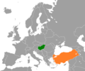
File:Hungary Turkey Locator.png
Appearance

Size of this preview: 720 × 600 pixels. Other resolutions: 288 × 240 pixels | 576 × 480 pixels | 922 × 768 pixels | 1,200 × 1,000 pixels.
Original file (1,200 × 1,000 pixels, file size: 81 KB, MIME type: image/png)
File history
Click on a date/time to view the file as it appeared at that time.
| Date/Time | Thumbnail | Dimensions | User | Comment | |
|---|---|---|---|---|---|
| current | 03:25, 1 February 2021 |  | 1,200 × 1,000 (81 KB) | Aquintero82 | Updated map |
| 20:09, 15 September 2017 |  | 1,200 × 1,000 (50 KB) | Fobos92 | . | |
| 16:58, 22 December 2008 |  | 1,200 × 1,000 (65 KB) | Turkish Flame~commonswiki | {{Information |Description={{en|1=Location of '''Hungary''' and '''Turkey'''.}} |Source=Own work by uploader |Author=Turkish Flame |Date=December 22, 2008 |Permission= |other_versions= }} <!--{{ImageUpload|full}}--> [[Category:Maps |
File usage
The following 2 pages use this file:
Global file usage
The following other wikis use this file:
- Usage on az.wikipedia.org
- Usage on fr.wikipedia.org
- Usage on he.wikipedia.org
- Usage on hu.wikipedia.org
- Usage on ru.wikipedia.org
- Usage on tr.wikipedia.org
- Usage on www.wikidata.org
