Jump to content

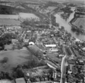
File:Hampton April 1946.png

Page contents not supported in other languages.
This is a file from the Wikimedia Commons
From Wikipedia, the free encyclopedia

Original file (1,828 × 1,800 pixels, file size: 3.83 MB, MIME type: image/png)

Summary

Description
English: Aerial photo of Hampton taken 11 April 1946 showing Station Road with the Meux Cottages terrace leading to St Mary's Church, the Beveree (left of frame) and associated parkland, and Castle House (centre frame). Hurst Park Racecourse, Tagg's Island and Hampton Court Palace are top right of frame.
Date
Source Public domain
Author Unknown authorUnknown author

Licensing

Public domain

This work is in the public domain in its country of origin and other countries and areas where the copyright term is the author's life plus 70 years or fewer.


You must also include a United States public domain tag to indicate why this work is in the public domain in the United States.
This file has been identified as being free of known restrictions under copyright law, including all related and neighboring rights.

Captions

Aerial photo of Hampton taken 11 April 1946 showing Station Road and Meux Cottages terrace leading to St Mary's Church, the Beveree (left) and parkland, Castle House (centre), and Tagg's Island and Hampton Court Palace (top right)

Items portrayed in this file

depicts

File history

Click on a date/time to view the file as it appeared at that time.

Date/TimeThumbnailDimensionsUserComment
current20:18, 15 April 2024Thumbnail for version as of 20:18, 15 April 20241,828 × 1,800 (3.83 MB)Orwell'sElephantUploaded a work by Unknown from Public domain with UploadWizard

The following page uses this file:

Metadata