Jump to content

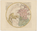
File:Hémisphère septentrional pour voir plus distinctoment les terres arctiques 11-c.130-1740.png

Page contents not supported in other languages.
This is a file from the Wikimedia Commons
From Wikipedia, the free encyclopedia

Original file (12,915 × 10,960 pixels, file size: 214.73 MB, MIME type: image/png)

Summary

Warning The original file is very high-resolution. It might not load properly or could cause your browser to freeze when opened at full size. Open in ZoomViewer
Title
Français : Hemisphère septentrional pour voir plus diftinctoment les terres arctiques
  
Date
Source
institution QS:P195,Q16506987
11-c.130-1740
Creator
Guillaume Delisle (1675-1726)
Permission
(Reusing this file)
This is a faithful photographic reproduction of a two-dimensional, public domain work of art. The work of art itself is in the public domain for the following reason:
Public domain

This work is in the public domain in its country of origin and other countries and areas where the copyright term is the author's life plus 70 years or fewer.


This work is in the public domain in the United States because it was published (or registered with the U.S. Copyright Office) before January 1, 1929.

This file has been identified as being free of known restrictions under copyright law, including all related and neighboring rights.
The official position taken by the Wikimedia Foundation is that "faithful reproductions of two-dimensional public domain works of art are public domain".
This photographic reproduction is therefore also considered to be in the public domain in the United States. In other jurisdictions, re-use of this content may be restricted; see Reuse of PD-Art photographs for details.
 Geotemporal data
Map location
Français : Arctique
Georeferencing Georeference the map in Wikimaps Warper If inappropriate please set warp_status = skip to hide.
 Bibliographic data
Place of publication Amsterdam
Publisher
Reinier Ottens (1720-1751)
 Archival data
institution QS:P195,Q1067935
Accession number
11-c.130-1740
Dimensions height: 46 cm (18.1 in); width: 47 cm (18.5 in)
dimensions QS:P2048,46U174728
dimensions QS:P2049,47U174728
Medium Copperplate print
Notes

Hemisphère septentrional pour voir plus diftinctoment [i.e. distinctement] les terres arctiques / par Guillaume Delisle de l’Académie Rle. de Sciences ; corrigée de nouveau sur la carte de Mr. Johannes Kyrilow [...] et ou est indiqué le Païs de Kamschahtka [...]

(W 180°--E 180°/N 90°--S 0°)

Captions

Add a one-line explanation of what this file represents

File history

Click on a date/time to view the file as it appeared at that time.

Date/TimeThumbnailDimensionsUserComment
current20:27, 14 March 2019Thumbnail for version as of 20:27, 14 March 201912,915 × 10,960 (214.73 MB)CephasUser created page with UploadWizard

The following page uses this file:

Metadata