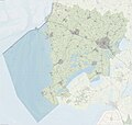
File:Gem-SudwestFryslan-OpenTopo.jpg
Appearance

Size of this preview: 629 × 600 pixels. Other resolutions: 252 × 240 pixels | 503 × 480 pixels | 805 × 768 pixels | 1,074 × 1,024 pixels | 2,148 × 2,048 pixels | 14,027 × 13,375 pixels.
Original file (14,027 × 13,375 pixels, file size: 13.81 MB, MIME type: image/jpeg)
File history
Click on a date/time to view the file as it appeared at that time.
| Date/Time | Thumbnail | Dimensions | User | Comment | |
|---|---|---|---|---|---|
| current | 15:34, 24 September 2023 |  | 14,027 × 13,375 (13.81 MB) | Janwillemvanaalst | Map layers update, September 2023 |
| 12:35, 17 September 2022 |  | 17,317 × 16,512 (26.87 MB) | Janwillemvanaalst | Map layers update, September 2022 | |
| 18:27, 22 June 2021 |  | 17,317 × 16,512 (26.89 MB) | Janwillemvanaalst | Map layers update, 30 June 2021 | |
| 17:14, 4 November 2020 |  | 17,317 × 16,512 (26.87 MB) | Janwillemvanaalst | Map layers update, Sept. 2020 | |
| 09:28, 22 April 2019 |  | 17,321 × 16,520 (26.49 MB) | Janwillemvanaalst | Map layers update, April 2019 | |
| 19:48, 1 January 2018 |  | 17,321 × 16,520 (26.46 MB) | Janwillemvanaalst | New municipal borders as of 2018. Also map layer updates. | |
| 18:27, 29 September 2017 |  | 17,321 × 16,520 (26.66 MB) | Janwillemvanaalst | Map layers update, Sept. 2017 | |
| 16:43, 30 October 2016 |  | 17,118 × 15,515 (60.15 MB) | Janwillemvanaalst | Map layers update, Oct. 2016 | |
| 09:11, 1 January 2016 |  | 17,118 × 15,515 (64.11 MB) | Janwillemvanaalst | Map layers update, Dec. 2015 | |
| 16:49, 19 July 2015 |  | 17,120 × 15,517 (65.4 MB) | Janwillemvanaalst | Map layers update, June 2015 |
File usage
The following page uses this file:
Global file usage
The following other wikis use this file:
- Usage on ar.wikipedia.org
- Usage on ca.wikipedia.org
- Usage on fy.wikipedia.org
- Usage on gl.wikipedia.org
- Usage on nl.wikipedia.org
- Usage on ru.wikipedia.org
- Usage on uk.wikipedia.org
- Usage on www.wikidata.org
- Usage on zea.wikipedia.org
