
File:East and West Florida 1803 Cary Map.png

Size of this preview: 799 × 600 pixels. Other resolutions: 320 × 240 pixels | 640 × 480 pixels | 846 × 635 pixels.
Original file (846 × 635 pixels, file size: 1.37 MB, MIME type: image/png)
| This is a file from the Wikimedia Commons. Information from its description page there is shown below. Commons is a freely licensed media file repository. You can help. |
Summary
| Description |
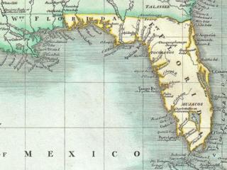
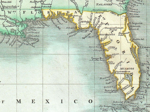
English: Excerpt from a beautiful example of John Cary’s important 1803 map of Florida, Central America and the West Indies. Covers from Texas (called Cenis) eastward to the Carolinas and the Bahamas, and then southward past Florida and the West Indies to include all of Central America and the northern part of South America. Offers superb detail throughout, especially regarding Florida and the Caribbean. In the North America section of the map Georgia is shown extending westward as far as the Mississippi River despite the creation of the Mississippi Territory in 1798. Florida is divided at the Apalachicola River into eastern and western sections. West Florida, ostensibly part of the Louisiana Purchase, was claimed by the Spanish and remained under their control until 1812. Lists numerous place names along the Mississippi River including Davion’s Rocks, Ft. Bosalie, Ft. Francis (destroyed in 1729), New Madrid and Old Fort, among others. In modern day Texas, called Cenis here, Cary lists eight place names as well as both the 1685 settlement founded by La Salle on the Gulf coast, and the place further inland where, in 1687, he was murdered. All in all, one of the most interesting and attractive atlas maps of the West Indies to appear in first ten years of the 19th century. Prepared in 1803 by John Cary for issue in his magnificent 1808 New Universal Atlas. |
| Date | |
| Source | Cary, John, Cary's New Universal Atlas, containing distinct maps of all the principal states and kingdoms throughout the World. From the latest and best authorities extant. London: Printed for J. Cary, Engraver and Map-seller, No. 181, near Norfolk Street, Strand, 1808. http://www.geographicus.com/P/AntiqueMap/WestIndies-cary-1803 |
| Author | John Cary |
Licensing
|
This is a faithful photographic reproduction of a two-dimensional, public domain work of art. The work of art itself is in the public domain for the following reason:
The official position taken by the Wikimedia Foundation is that "faithful reproductions of two-dimensional public domain works of art are public domain".
This photographic reproduction is therefore also considered to be in the public domain in the United States. In other jurisdictions, re-use of this content may be restricted; see Reuse of PD-Art photographs for details. | ||||
File history
Click on a date/time to view the file as it appeared at that time.
| Date/Time | Thumbnail | Dimensions | User | Comment | |
|---|---|---|---|---|---|
| current | 01:23, 17 November 2020 | | 846 × 635 (1.37 MB) | Jeff in CA | Uploaded a work by John Cary from Cary, John, ''Cary's New Universal Atlas, containing distinct maps of all the principal states and kingdoms throughout the World. From the latest and best authorities extant''. London: Printed for J. Cary, Engraver and Map-seller, No. 181, near Norfolk Street, Strand, 1808. http://www.geographicus.com/P/AntiqueMap/WestIndies-cary-1803 with UploadWizard |
File usage
The following 2 pages use this file:
Global file usage
The following other wikis use this file:
- Usage on he.wikipedia.org