
File:Departementmt.png
Size of this preview: 743 × 599 pixels. Other resolutions: 298 × 240 pixels | 595 × 480 pixels | 900 × 726 pixels.
Original file (900 × 726 pixels, file size: 506 KB, MIME type: image/png)
| This is a file from the Wikimedia Commons. Information from its description page there is shown below. Commons is a freely licensed media file repository. You can help. |
Summary
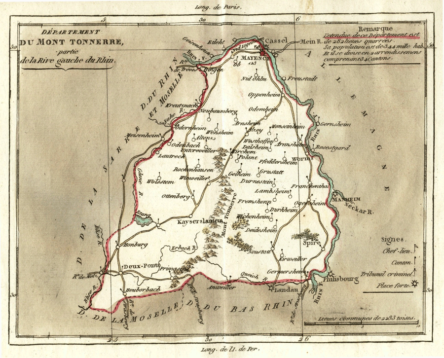
| Description | Zeitgenössische Karte des Départements du Mont Tonnerre (Anfang 19. Jahrhundert) | ||||
| Date | September 2006 (upload date) | ||||
| Source | Museum bei der Kaiserpfalz, Ingelheim | ||||
| Author | Louis Brion. Voyage dans la ci-devant Belgique, et sur la rive gauche du Rhin. Paris 1802 | ||||
| Permission (Reusing this file) |
|
||||
File history
Click on a date/time to view the file as it appeared at that time.
| Date/Time | Thumbnail | Dimensions | User | Comment | |
|---|---|---|---|---|---|
| current | 06:57, 7 September 2006 | | 900 × 726 (506 KB) | Martin Bahmann | == Beschreibung == {{Information |Description= Zeitgenössische Karte des Départements du Mont Tonnerre (Anfang 19. Jahrhundert) |Source= Museum bei der Kaiserpfalz, Ingelheim |Date= September 2006 |Author= |Permission= s.u. |other_versions= }} == Lic |
File usage
The following 4 pages use this file:
Global file usage
The following other wikis use this file:
- Usage on de.wikipedia.org
- Usage on eo.wikipedia.org
- Usage on es.wikipedia.org
- Usage on fr.wikipedia.org
- Usage on fr.wiktionary.org
- Usage on it.wikipedia.org
- Usage on nl.wikipedia.org
- Usage on pt.wikipedia.org
- Usage on ro.wikipedia.org
- Usage on ru.wikipedia.org
- Usage on uk.wikipedia.org
- Usage on zh.wikipedia.org