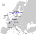
File:DNL international route map.svg
Appearance

Size of this PNG preview of this SVG file: 454 × 450 pixels. Other resolutions: 242 × 240 pixels | 484 × 480 pixels | 775 × 768 pixels | 1,033 × 1,024 pixels | 2,066 × 2,048 pixels.
Original file (SVG file, nominally 454 × 450 pixels, file size: 325 KB)
File history
Click on a date/time to view the file as it appeared at that time.
| Date/Time | Thumbnail | Dimensions | User | Comment | |
|---|---|---|---|---|---|
| current | 17:26, 25 December 2022 |  | 454 × 450 (325 KB) | Iktsokh | Extended Soviet borders |
| 01:50, 19 November 2022 |  | 454 × 450 (365 KB) | M.Bitton | Reverted to version as of 13:49, 2 March 2010 (UTC): I suggest you read COM:OVERWRITE | |
| 18:36, 18 November 2022 |  | 454 × 450 (322 KB) | Рагин1987 | Extended map | |
| 13:49, 2 March 2010 |  | 454 × 450 (365 KB) | Arsenikk | {{Information |Description={{en|1=Route map of Det Norske Luftfartselskap's international services in 1947. Source: [http://www.timetableimages.com/i-mn/no4710i.jpg] |Source=*File:Blank_map_of_Europe_EU27_iso3166-1_code.svg |Date=2010-03-02 13:47 (U |
File usage
The following page uses this file:
