
File:Clerkenwell 1805 Cartographer; Tyrer, James.jpg

Original file (712 × 758 pixels, file size: 253 KB, MIME type: image/jpeg)
| This is a file from the Wikimedia Commons. Information from its description page there is shown below. Commons is a freely licensed media file repository. You can help. |
Summary
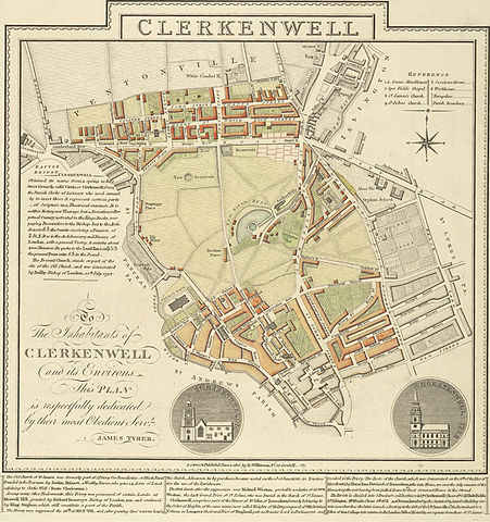
A plan of Clerkenwell in London by James Tyrer, 1805. The old part of Clerkenwell, which lies immediately to the north of the City of London, is at the bottom of the map. Development has occurred along much of Clerkenwell's north-axis of St John Street. The then recently developed Pentonville, which lay in the parish of Clerkenwell, but was otherwise more closely connected with Islington (which was a separate parish and is shown in part in grey at the top right) is at the top of the map.
Licensing
|
This work is in the public domain in its country of origin and other countries and areas where the copyright term is the author's life plus 70 years or fewer. | |
| This file has been identified as being free of known restrictions under copyright law, including all related and neighboring rights. | |
File history
Click on a date/time to view the file as it appeared at that time.
| Date/Time | Thumbnail | Dimensions | User | Comment | |
|---|---|---|---|---|---|
| current | 00:14, 16 February 2006 | | 712 × 758 (253 KB) | Merchbow~commonswiki | A plan of Clerkenwell in London by James Tyrer, 1805. The old part of Clerkenwell, which lies immediately to the north of the City of London, is at the bottom of the map. Development has occurred along much of Clerkenwell's north-axis of St John Street. T |
File usage
The following page uses this file:
Global file usage
The following other wikis use this file:
- Usage on ar.wikipedia.org
- Usage on fi.wikipedia.org
- Usage on it.wikipedia.org
- Usage on no.wikipedia.org
- Usage on pl.wikipedia.org
- Usage on vi.wikipedia.org