File:Circum-Superior Belt map.jpg
Appearance
Circum-Superior_Belt_map.jpg (549 × 576 pixels, file size: 175 KB, MIME type: image/jpeg)
File history
Click on a date/time to view the file as it appeared at that time.
| Date/Time | Thumbnail | Dimensions | User | Comment | |
|---|---|---|---|---|---|
| current | 01:00, 14 December 2011 |  | 549 × 576 (175 KB) | Ciaurlec | Colours reverted |
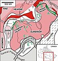
| 22:40, 8 January 2010 |  | 549 × 576 (90 KB) | Black Tusk | {{Information |Description={{en|1=Map of cratons and orogenies associated with the formation of the Circum-Superior Belt. A = New Quebec Orogen, B = Cape Smith Belt, C = Eastern Hudson Bay, D = Thompson region, E = Animikie Basin, F = Western interior of |
File usage
The following page uses this file:
Global file usage
The following other wikis use this file:
- Usage on it.wikipedia.org
- Usage on www.wikidata.org

