Jump to content

File:Chinesische Mauer (Ortelius 1584).jpg

Page contents not supported in other languages.
This is a file from the Wikimedia Commons
From Wikipedia, the free encyclopedia

Original file (1,530 × 1,710 pixels, file size: 699 KB, MIME type: image/jpeg)

Summary

Description
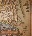
English: Detail of the map of China engraved by Abraham Ortelius (1584), the first map of China printed in a European atlas. "C.Paquin" is Beijing (Peking).

The Latin text next to the Great Wall says: "Murus quadringentarum leucarum inter montium crepidines a Rege Chinæ contra Tartarorum ab hac parte eruptiones extructus."

Translation to English: "A wall of four hundred miles has been constructed between the edges of the mountains by the King of China against the invasions of the Tartars in this part."
Deutsch: Detailaufnahme von der China-Karte von Abraham Ortelius (1584), der ersten in einem abendländischen Atlas erscheinenden Karte von China. Die Karte ist nach Westen ausgerichtet. Die Chinesische Mauer verläuft auf einer Länge von etwa 400 Meilen (also viel zu kurz). Rechts, also im Norden, sind schöne mongolische Jurten zu sehen. Man beachte auch die Windwagen, die in China schon im 6. Jahrhundert nach Christus entwickelt worden sind.

Der lateinische Text entlang der Chinesischen Mauer lautet: "Murus quadringentarum leucarum inter montium crepidines a Rege Chinæ contra Tartarorum ab hac parte eruptiones extructus."

Auf Deutsch übersetzt: "Eine vierhundert Meilen lange Mauer wurde zwischen den Bergkämmen vom König von China gegen die Invasionen der Ta(r)taren in diesem Gebiet erstellt."
Date
Source Private collection
institution QS:P195,Q768717
Author
Abraham Ortelius  (1527–1598)  wikidata:Q232916 s:it:Autore:Abraham Ortelius
 
Abraham Ortelius
Alternative names
Ortels, Oertel, Orthellius, Wortels
Description Spanish-Dutch cartographer, historian, engraver, geographer, archaeologist and afsetter
Date of birth/death 14 April 1527 Edit this at Wikidata 28 June 1598 / 29 June 1598 Edit this at Wikidata
Location of birth/death Antwerp Edit this at Wikidata Antwerp Edit this at Wikidata
Work location
Authority file
creator QS:P170,Q232916
Other versions Entire map:

Licensing

Public domain

This work is in the public domain in its country of origin and other countries and areas where the copyright term is the author's life plus 100 years or fewer.


You must also include a United States public domain tag to indicate why this work is in the public domain in the United States.
This file has been identified as being free of known restrictions under copyright law, including all related and neighboring rights.

Captions

Add a one-line explanation of what this file represents

Items portrayed in this file

depicts

image/jpeg

d88a96d732ef8ac9a75d65fa5d945f66d77ad3d1

715,439 byte

1,710 pixel

1,530 pixel

File history

Click on a date/time to view the file as it appeared at that time.

Date/TimeThumbnailDimensionsUserComment
current18:13, 2 March 2009Thumbnail for version as of 18:13, 2 March 20091,530 × 1,710 (699 KB)Altiplano{{Information |Description={{en|1=Detail of the map of China engraved by Abraham Ortelius (1584), the first map of China printed in a european atlas. The latin text next to the Great Wall sais: "Murus quadringentarum leucarum inter montium crepidines a Re

The following page uses this file:

Global file usage

The following other wikis use this file:

Metadata