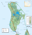
File:Carte Miscou.svg
Appearance

Size of this PNG preview of this SVG file: 560 × 599 pixels. Other resolutions: 224 × 240 pixels | 449 × 480 pixels | 718 × 768 pixels | 957 × 1,024 pixels | 1,915 × 2,048 pixels | 1,150 × 1,230 pixels.
Original file (SVG file, nominally 1,150 × 1,230 pixels, file size: 341 KB)
File history
Click on a date/time to view the file as it appeared at that time.
| Date/Time | Thumbnail | Dimensions | User | Comment | |
|---|---|---|---|---|---|
| current | 12:29, 8 June 2008 |  | 1,150 × 1,230 (341 KB) | Dr Wilson | enlevé les marais |
| 02:55, 11 May 2008 |  | 1,150 × 1,230 (355 KB) | Dr Wilson | corrections diverses | |
| 02:21, 11 May 2008 |  | 1,150 × 1,230 (355 KB) | Dr Wilson | {{Information |Description={{fr}}Carte topographique de Miscou, au Nouveau-Brunswick (Canada).{{en}}Topographic map of Miscou, New Brunswick (Canada). |Source=travail personnel, basé sur les donnés de l'[http://atlas.nrcan.gc.ca/site/francais/maps/topo/ |
File usage
The following page uses this file:
Global file usage
The following other wikis use this file:
- Usage on es.wikipedia.org
- Usage on fr.wikipedia.org
- Usage on no.wikipedia.org

