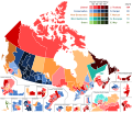
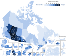
File:Canada Election 2015 Results Map.svg
Appearance

Size of this PNG preview of this SVG file: 767 × 600 pixels. Other resolutions: 307 × 240 pixels | 614 × 480 pixels | 982 × 768 pixels | 1,280 × 1,001 pixels | 2,560 × 2,002 pixels | 1,046 × 818 pixels.
Original file (SVG file, nominally 1,046 × 818 pixels, file size: 1.33 MB)
File history
Click on a date/time to view the file as it appeared at that time.
| Date/Time | Thumbnail | Dimensions | User | Comment | |
|---|---|---|---|---|---|
| current | 05:32, 28 February 2022 |  | 1,046 × 818 (1.33 MB) | CaelemSG | Reverted to version as of 04:56, 22 April 2018 (UTC) - Made an oopsie, meant to update 2021. |
| 05:28, 28 February 2022 |  | 512 × 400 (1.26 MB) | CaelemSG | Fixed the GPC vote count, was incorrect, duplicate of NDP vote number. | |
| 04:56, 22 April 2018 |  | 1,046 × 818 (1.33 MB) | DrRandomFactor | New strength chart format. | |
| 17:29, 30 October 2017 |  | 1,046 × 818 (1.39 MB) | DrRandomFactor | Fixed error with Gaspésie—Les Îles-de-la-Madeleine. The islands were incorrectly grouped with Manicougan, this has been fixed. | |
| 20:27, 24 October 2017 |  | 1,046 × 818 (1.39 MB) | DrRandomFactor | Fixed formatting issues with the Toronto inset. | |
| 06:19, 19 October 2017 |  | 1,046 × 818 (1.39 MB) | DrRandomFactor | Fixed formatting errors in inset boundaries. | |
| 06:08, 19 October 2017 |  | 1,046 × 818 (1.39 MB) | DrRandomFactor | New format. | |
| 21:41, 11 August 2017 |  | 3,254 × 2,768 (953 KB) | DrRandomFactor | Update to the NDP orange shades. | |
| 19:40, 3 May 2017 |  | 3,254 × 2,768 (955 KB) | DrRandomFactor | Adjusted boundaries in the Ottawa region for viewing purposes. | |
| 17:37, 19 April 2017 |  | 3,254 × 2,768 (959 KB) | DrRandomFactor | Adjusted the colour for the Conservative 40-49% party vote indicator, as well as recoloured the respective ridings. |
File usage
The following page uses this file:
Global file usage
The following other wikis use this file:
- Usage on de.wikipedia.org


