
File:Bessarabia.png

Size of this preview: 537 × 599 pixels. Other resolutions: 215 × 240 pixels | 544 × 607 pixels.
Original file (544 × 607 pixels, file size: 49 KB, MIME type: image/png)
| This is a file from the Wikimedia Commons. Information from its description page there is shown below. Commons is a freely licensed media file repository. You can help. |
Summary
| Description |
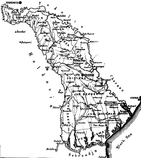
English: The map of the region of Bessarabia (1812-1917) Română: Harta Basarabiei Русский: Карта Бессарабии |
| Date | |
| Source | http://depts.washington.edu/cartah/text_archive/clark/b_22.jpg |
| Author | Celeron |
Licensing
|
This work is in the public domain in its country of origin and other countries and areas where the copyright term is the author's life plus 70 years or fewer. | |
| This file has been identified as being free of known restrictions under copyright law, including all related and neighboring rights. | |
Comment 1
better version of map at 
Comment 2
This map is from the book "Bessarabia, Russia, and Roumania on the Black Sea" by Charles Upson Clark.
An electronic version of the book is available online: http://depts.washington.edu/cartah/text_archive/clark/meta_pag.shtml
File history
Click on a date/time to view the file as it appeared at that time.
| Date/Time | Thumbnail | Dimensions | User | Comment | |
|---|---|---|---|---|---|
| current | 20:52, 19 May 2006 | | 544 × 607 (49 KB) | Zserghei | This image was copied from wikipedia:en. The original description was: {{PD}} ==Comment 1== better version of map at Image:Bessarabia.jpg ==Comment 2== This map is from the book "Bessarabia, Russia, and Roumania on the Black Sea" by Charles Upson C |
| 00:47, 3 October 2005 |  | 544 × 607 (49 KB) | Celeron | {{pd}} bessarabia's map |
File usage
The following pages on the English Wikipedia use this file (pages on other projects are not listed):
Global file usage
The following other wikis use this file:
- Usage on ar.wikipedia.org
- Usage on ast.wikipedia.org
- Usage on beta.wikiversity.org
- Usage on ca.wikipedia.org
- Usage on cs.wikipedia.org
- Usage on dsb.wikipedia.org
- Usage on es.wikipedia.org
- Usage on eu.wikipedia.org
- Usage on id.wikipedia.org
- Usage on is.wikipedia.org
- Usage on it.wikipedia.org
- Usage on ko.wikipedia.org
- Usage on mk.wikipedia.org
- Usage on ms.wikipedia.org
- Usage on nl.wikipedia.org
- Usage on no.wikipedia.org
- Usage on pl.wikipedia.org
- Usage on pnb.wikipedia.org
- Usage on ro.wikipedia.org
- Usage on sl.wikipedia.org
- Usage on sq.wikipedia.org
- Usage on sv.wikipedia.org
- Usage on tr.wikipedia.org
- Usage on uk.wikipedia.org
- Usage on ur.wikipedia.org
- Usage on vi.wikipedia.org
- Usage on zh.wikipedia.org