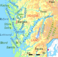
File:Bergen Hardangerfjord.png
Appearance
Bergen_Hardangerfjord.png (511 × 506 pixels, file size: 97 KB, MIME type: image/png)
File history
Click on a date/time to view the file as it appeared at that time.
| Date/Time | Thumbnail | Dimensions | User | Comment | |
|---|---|---|---|---|---|
| current | 21:50, 30 January 2008 |  | 511 × 506 (97 KB) | Ulamm | |
| 15:19, 30 January 2008 |  | 511 × 506 (97 KB) | Ulamm | ||
| 20:08, 29 January 2008 |  | 511 × 506 (98 KB) | Ulamm | ||
| 14:12, 29 January 2008 |  | 511 × 506 (97 KB) | Ulamm | ||
| 14:08, 29 January 2008 |  | 511 × 506 (97 KB) | Ulamm | == Summary == {{Information |Description= Physical map of Fjords and Sunds around Bergen and Hardangerfjord, showing the position of Fensfjord, Hjeltefjord, Osterøy, Osterfjord, Vedfjord, Sørfjord, Raunefjord,Børnafjord,Lokksund,Langenuen, Stokksund an |
File usage
The following page uses this file:
Global file usage
The following other wikis use this file:
- Usage on bg.wikipedia.org
- Usage on cs.wikipedia.org
- Usage on da.wikipedia.org
- Usage on de.wikipedia.org
- Usage on es.wikipedia.org
- Usage on et.wikipedia.org
- Usage on fi.wikipedia.org
- Usage on fr.wikipedia.org
- Usage on is.wikipedia.org
- Usage on it.wikipedia.org
- Usage on nl.wiktionary.org
- Usage on nn.wikipedia.org
- Usage on no.wikipedia.org
- Usage on ru.wikipedia.org
- Usage on sl.wikipedia.org
- Usage on sv.wikipedia.org
- Usage on uk.wikipedia.org
- Usage on zh.wikipedia.org


